Ngampelrejo geodata
Ngampelrejo (East Java) is a seat of a fourth-order administrative division; located in Indonesia in Asia/Jakarta (GMT+7) time zone. In our database, there are 407 cities with bigger population. Compared to other cities in Indonesia, 72.8% of cities are located further ↑North; 61.2% of cities are located further ←West and 79.9% of cities have higher elevation than Ngampelrejo. Note1


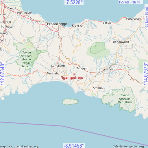
Ngampelrejo GPS coordinates[2]
8° 13' 9.48" South, 113° 22' 35.76" East
| Map corner | latitude | longitude |
|---|---|---|
| Upper-left | -7.5228°, | 112.67348° |
| Center: | -8.2193°, | 113.3766° |
| Lower-right: | -8.91458°, | 114.07973° |
| Map W x H: | 154.8×154.8 km | = 96.2×96.2mi |
| max Lat: | 5.88969° ⇑72.8% North |
| Ngampelrejo: | -8.2193° |
| min Lat: | ⇓27.2% South -10.934° |
| min Long | Ngampelrejo | max Long |
| 95.1345° | 113.3766° | 140.9419° |
| W 61.2%⇐ | ⇒38.8% E |
Elevation
Elevation of Ngampelrejo is 19 m = 62 ft, and this is 210.7 m = 691 ft below average elevation for this country.
| Max E: |
3185 m = 10449 ft | 79.9% |
| Avg. | 229.7 m = 754 ft | |
| Ngampelrejo | 19 m = 62 ft | |
Min E: |
-1 m = -3 ft | 20.1% |
See also: Indonesia elevation on elevation.city.
Geographical zone
Ngampelrejo is located in South Torrid zone (between Equator and Tropic of Capricorn). Distance of Equator is 913.9 km =567.9 mi to North.| Distance of | km | miles | from Ngampelrejo |
|---|---|---|---|
| Equator | 913.9 | 567.9 | to North |
| Tropic Capricorn | 1692 | 1051.4 | to South |
| Antarctic Circle | 6487.3 | 4031 | to South |
| South Pole | 9093.2 | 5650.3 | to South |


Nearby cities:
15 places around Ngampelrejo: (largest is in red/bold)
• Gadingrejo
6.6 km =4.1 mi,  105°
105°
• Gununglincingkrajan
7.2 km =4.5 mi,  124°
124°
• Kencong
7.2 km =4.5 mi,  188°
188°
• Kesambilerenkrajan
7.5 km =4.7 mi,  153°
153°
• Krajan A Wonorejo
7.5 km =4.7 mi,  175°
175°
• Krajan Dua Keting
7.3 km =4.5 mi,  228°
228°
• Krajan Dua Padomasan
6.4 km =4 mi,  258°
258°
• Krajan Rowokangkung
5.5 km =3.4 mi,  300°
300°
• Rejoagung
4.9 km =3 mi,  66°
66°
• Rowokangkung
5.9 km =3.7 mi, 298°
• Rowotengah
7 km =4.3 mi,  10°
10°
• Sebaren
3.6 km =2.2 mi,  236°
236°
• Sukoreno
4.1 km =2.5 mi,  140°
140°
• Wringinagung
2.1 km =1.3 mi,  51°
51°
• Yosowilangun
7.3 km =4.5 mi,  252°
252°
Sources, notices
• [Note1] Compared only with cities in Indonesia existing in our database
• [Src1] Map data: © OpenStreetMap contributors (CC-BY-SA)
• [Src2] Other city data from geonames.org with taken over terms of usage.
• [Src3] Geographical zone / Annual Mean Temperature by Robert A. Rohde @ Wikipedia
