Rempungtimur Utara geodata
Rempungtimur Utara (West Nusa Tenggara) is a seat of a fourth-order administrative division; located in Indonesia in Asia/Makassar (GMT+8) time zone. In our database, there are 407 cities with bigger population. Compared to other cities in Indonesia, 87.1% of cities are located further ↑North; 77.6% of cities are located further ←West and 67.4% of cities have lower elevation than Rempungtimur Utara. Note1


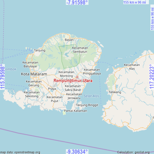
Rempungtimur Utara GPS coordinates[2]
8° 36' 42.48" South, 116° 29' 56.76" East
| Map corner | latitude | longitude |
|---|---|---|
| Upper-left | -7.91598°, | 115.79598° |
| Center: | -8.6118°, | 116.4991° |
| Lower-right: | -9.30634°, | 117.20223° |
| Map W x H: | 154.6×154.6 km | = 96.1×96.1mi |
| max Lat: | 5.88969° ⇑87.1% North |
| Rempungtimur Utara: | -8.6118° |
| min Lat: | ⇓12.9% South -10.934° |
| min Long | Rempungtimur Ut | max Long |
| 95.1345° | 116.4991° | 140.9419° |
| W 77.6%⇐ | ⇒22.4% E |
Elevation
Elevation of Rempungtimur Utara is 256 m = 840 ft, and this is 26.3 m = 86 ft above average elevation for this country.
| Max E: |
3185 m = 10449 ft | 32.6% |
| Rempungtimur Utara | 256 m 840 ft | |
| Avg. | 229.7 m = 754 ft | |
Min E: |
-1 m = -3 ft | 67.4% |
See also: Indonesia elevation on elevation.city.
Geographical zone
Rempungtimur Utara is located in South Torrid zone (between Equator and Tropic of Capricorn). Distance of Equator is 957.5 km =595 mi to North.| Distance of | km | miles | from Rempungtimur Utara |
|---|---|---|---|
| Equator | 957.5 | 595 | to North |
| Tropic Capricorn | 1648.4 | 1024.3 | to South |
| Antarctic Circle | 6443.6 | 4003.9 | to South |
| South Pole | 9049.5 | 5623.1 | to South |


Nearby cities:
15 places around Rempungtimur Utara: (largest is in red/bold)
• Anjani Barat
1.1 km =0.7 mi,  38°
38°
• Bongkemalik
3.8 km =2.4 mi,  123°
123°
• Danger Utara
4.4 km =2.7 mi,  269°
269°
• Gelumpang
3.3 km =2.1 mi,  58°
58°
• Gubuk Timuk
2.4 km =1.5 mi,  168°
168°
• Karangbaru
2.8 km =1.7 mi,  247°
247°
• Karangranjong
3.6 km =2.2 mi,  22°
22°
• Keroak
4.6 km =2.9 mi,  358°
358°
• Laukrurung
4 km =2.5 mi,  219°
219°
• Masbagik
2.7 km =1.7 mi,  244°
244°
• Muhajirin
4.4 km =2.7 mi,  147°
147°
• Nyiurtebel
2.7 km =1.7 mi,  180°
180°
• Paokmotong Utara
4.7 km =2.9 mi, 250°
• Setanggor
5.1 km =3.2 mi,  202°
202°
• Sukamulia
2.4 km =1.5 mi,  141°
141°
Sources, notices
• [Note1] Compared only with cities in Indonesia existing in our database
• [Src1] Map data: © OpenStreetMap contributors (CC-BY-SA)
• [Src2] Other city data from geonames.org with taken over terms of usage.
• [Src3] Geographical zone / Annual Mean Temperature by Robert A. Rohde @ Wikipedia
