Gelumpang geodata
Gelumpang (West Nusa Tenggara) is a seat of a fourth-order administrative division; located in Indonesia in Asia/Makassar (GMT+8) time zone. In our database, there are 407 cities with bigger population. Compared to other cities in Indonesia, 86.8% of cities are located further ↑North; 77.7% of cities are located further ←West and 65.9% of cities have lower elevation than Gelumpang. Note1


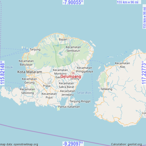
Gelumpang GPS coordinates[2]
8° 35' 47.04" South, 116° 31' 28.56" East
| Map corner | latitude | longitude |
|---|---|---|
| Upper-left | -7.90055°, | 115.82148° |
| Center: | -8.5964°, | 116.5246° |
| Lower-right: | -9.29097°, | 117.22773° |
| Map W x H: | 154.6×154.6 km | = 96.1×96.1mi |
| max Lat: | 5.88969° ⇑86.8% North |
| Gelumpang: | -8.5964° |
| min Lat: | ⇓13.2% South -10.934° |
| min Long | Gelumpang | max Long |
| 95.1345° | 116.5246° | 140.9419° |
| W 77.7%⇐ | ⇒22.3% E |
Elevation
Elevation of Gelumpang is 236 m = 774 ft, and this is 6.3 m = 21 ft above average elevation for this country.
| Max E: |
3185 m = 10449 ft | 34.1% |
| Gelumpang | 236 m 774 ft | |
| Avg. | 229.7 m = 754 ft | |
Min E: |
-1 m = -3 ft | 65.9% |
See also: Indonesia elevation on elevation.city.
Geographical zone
Gelumpang is located in South Torrid zone (between Equator and Tropic of Capricorn). Distance of Equator is 955.8 km =593.9 mi to North.| Distance of | km | miles | from Gelumpang |
|---|---|---|---|
| Equator | 955.8 | 593.9 | to North |
| Tropic Capricorn | 1650.1 | 1025.3 | to South |
| Antarctic Circle | 6445.3 | 4004.9 | to South |
| South Pole | 9051.2 | 5624.2 | to South |


Nearby cities:
15 places around Gelumpang: (largest is in red/bold)
• Aikmel
3.2 km =2 mi,  11°
11°
• Anjani Barat
2.2 km =1.4 mi,  248°
248°
• Bongkemalik
3.8 km =2.4 mi,  175°
175°
• Dasanlian Lauk
5 km =3.1 mi,  352°
352°
• Gubuk Timuk
4.7 km =2.9 mi,  209°
209°
• Karangbaru
6 km =3.7 mi,  242°
242°
• Karangranjong
2.1 km =1.3 mi,  319°
319°
• Kembangkerang Lauk Timur
4.5 km =2.8 mi,  18°
18°
• Keroak
4.1 km =2.5 mi,  314°
314°
• Masbagik
5.9 km =3.7 mi, 241°
• Muhajirin
5.5 km =3.4 mi, 184°
• Nyiurtebel
5.3 km =3.3 mi, 212°
• Rempungtimur Utara
3.3 km =2.1 mi, 238°
• Selong
6 km =3.7 mi,  172°
172°
• Sukamulia
3.8 km =2.4 mi,  200°
200°
Sources, notices
• [Note1] Compared only with cities in Indonesia existing in our database
• [Src1] Map data: © OpenStreetMap contributors (CC-BY-SA)
• [Src2] Other city data from geonames.org with taken over terms of usage.
• [Src3] Geographical zone / Annual Mean Temperature by Robert A. Rohde @ Wikipedia
