Wolomage geodata
Wolomage (East Nusa Tenggara) is a seat of a fourth-order administrative division; located in Indonesia in Asia/Makassar (GMT+8) time zone. In our database, there are 407 cities with bigger population. Compared to other cities in Indonesia, 89.3% of cities are located further ↑North; 87.3% of cities are located further ←West and 90.9% of cities have lower elevation than Wolomage. Note1


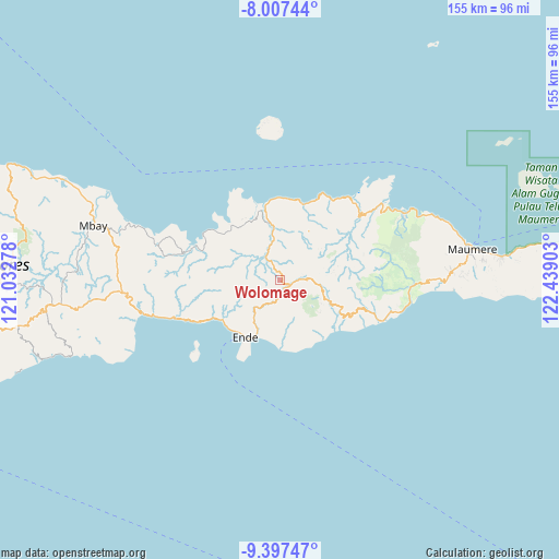
Wolomage GPS coordinates[2]
8° 42' 11.16" South, 121° 44' 9.24" East
| Map corner | latitude | longitude |
|---|---|---|
| Upper-left | -8.00744°, | 121.03278° |
| Center: | -8.7031°, | 121.7359° |
| Lower-right: | -9.39747°, | 122.43903° |
| Map W x H: | 154.6×154.6 km | = 96.1×96.1mi |
| max Lat: | 5.88969° ⇑89.3% North |
| Wolomage: | -8.7031° |
| min Lat: | ⇓10.7% South -10.934° |
| min Long | Wolomage | max Long |
| 95.1345° | 121.7359° | 140.9419° |
| W 87.3%⇐ | ⇒12.7% E |
Elevation
Elevation of Wolomage is 670 m = 2198 ft, and this is 440.3 m = 1445 ft above average elevation for this country.
| Max E: |
3185 m = 10449 ft | 9.1% |
| Wolomage | 670 m 2198 ft | |
| Avg. | 229.7 m = 754 ft | |
Min E: |
-1 m = -3 ft | 90.9% |
See also: Indonesia elevation on elevation.city.
Geographical zone
Wolomage is located in South Torrid zone (between Equator and Tropic of Capricorn). Distance of Equator is 967.7 km =601.3 mi to North.| Distance of | km | miles | from Wolomage |
|---|---|---|---|
| Equator | 967.7 | 601.3 | to North |
| Tropic Capricorn | 1638.2 | 1017.9 | to South |
| Antarctic Circle | 6433.5 | 3997.6 | to South |
| South Pole | 9039.4 | 5616.8 | to South |


Nearby cities:
15 places around Wolomage: (largest is in red/bold)
• Aefeo
9.6 km =6 mi,  225°
225°
• Detusoko
3.1 km =1.9 mi,  118°
118°
• Kengga
6.7 km =4.2 mi,  201°
201°
• Londe
10.8 km =6.7 mi,  355°
355°
• Mbani
9.1 km =5.7 mi,  282°
282°
• Nduaria
10.2 km =6.3 mi,  95°
95°
• Nuajena
3.2 km =2 mi,  158°
158°
• Puutuga
11.2 km =7 mi,  187°
187°
• Roa
6.3 km =3.9 mi, 197°
• Saga
7.4 km =4.6 mi,  180°
180°
• Tendaleo
7.3 km =4.5 mi,  327°
327°
• Welamosa
11 km =6.8 mi,  349°
349°
• Wolofeo
6.5 km =4 mi,  248°
248°
• Wolomoni
4.6 km =2.9 mi,  168°
168°
• Wolomuku
11 km =6.8 mi,  2°
2°
Sources, notices
• [Note1] Compared only with cities in Indonesia existing in our database
• [Src1] Map data: © OpenStreetMap contributors (CC-BY-SA)
• [Src2] Other city data from geonames.org with taken over terms of usage.
• [Src3] Geographical zone / Annual Mean Temperature by Robert A. Rohde @ Wikipedia
