Sokonaja geodata
Sokonaja (East Nusa Tenggara) is a seat of a fourth-order administrative division; located in Indonesia in Asia/Makassar (GMT+8) time zone. In our database, there are 407 cities with bigger population. Compared to other cities in Indonesia, 86.7% of cities are located further ↑North; 87.9% of cities are located further ←West and 91.4% of cities have lower elevation than Sokonaja. Note1


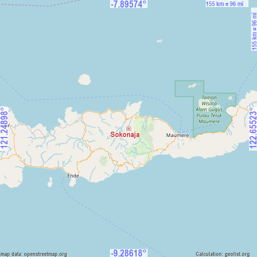
Sokonaja GPS coordinates[2]
8° 35' 29.76" South, 121° 57' 7.56" East
| Map corner | latitude | longitude |
|---|---|---|
| Upper-left | -7.89574°, | 121.24898° |
| Center: | -8.5916°, | 121.9521° |
| Lower-right: | -9.28618°, | 122.65523° |
| Map W x H: | 154.6×154.6 km | = 96.1×96.1mi |
| max Lat: | 5.88969° ⇑86.7% North |
| Sokonaja: | -8.5916° |
| min Lat: | ⇓13.3% South -10.934° |
| min Long | Sokonaja | max Long |
| 95.1345° | 121.9521° | 140.9419° |
| W 87.9%⇐ | ⇒12.1% E |
Elevation
Elevation of Sokonaja is 688 m = 2257 ft, and this is 458.3 m = 1504 ft above average elevation for this country.
| Max E: |
3185 m = 10449 ft | 8.6% |
| Sokonaja | 688 m 2257 ft | |
| Avg. | 229.7 m = 754 ft | |
Min E: |
-1 m = -3 ft | 91.4% |
See also: Indonesia elevation on elevation.city.
Geographical zone
Sokonaja is located in South Torrid zone (between Equator and Tropic of Capricorn). Distance of Equator is 955.3 km =593.6 mi to North.| Distance of | km | miles | from Sokonaja |
|---|---|---|---|
| Equator | 955.3 | 593.6 | to North |
| Tropic Capricorn | 1650.6 | 1025.6 | to South |
| Antarctic Circle | 6445.9 | 4005.3 | to South |
| South Pole | 9051.8 | 5624.5 | to South |


Nearby cities:
15 places around Sokonaja: (largest is in red/bold)
• Detuleda
12.2 km =7.6 mi,  124°
124°
• Feondari
12.3 km =7.6 mi,  133°
133°
• Funga
9.4 km =5.8 mi,  155°
155°
• Kanganara
12.7 km =7.9 mi,  253°
253°
• Kotabaru
10 km =6.2 mi,  25°
25°
• Loboniki
9.2 km =5.7 mi,  342°
342°
• Lokolande
7.6 km =4.7 mi,  16°
16°
• Magepanda
11.6 km =7.2 mi,  65°
65°
• Nggesa
14.7 km =9.1 mi,  265°
265°
• Niopanda
6.9 km =4.3 mi,  310°
310°
• Nuamuri
10 km =6.2 mi, 272°
• Ratenggoji
11.1 km =6.9 mi,  200°
200°
• Retenggoma
15.2 km =9.4 mi, 123°
• Woloau
8.8 km =5.5 mi, 127°
• Wolofeo
15 km =9.3 mi, 164°
Sources, notices
• [Note1] Compared only with cities in Indonesia existing in our database
• [Src1] Map data: © OpenStreetMap contributors (CC-BY-SA)
• [Src2] Other city data from geonames.org with taken over terms of usage.
• [Src3] Geographical zone / Annual Mean Temperature by Robert A. Rohde @ Wikipedia
