Magepanda geodata
Magepanda (East Nusa Tenggara) is a seat of a fourth-order administrative division; located in Indonesia in Asia/Makassar (GMT+8) time zone. In our database, there are 407 cities with bigger population. Compared to other cities in Indonesia, 85.2% of cities are located further ↑North; 88.2% of cities are located further ←West and 72.7% of cities have higher elevation than Magepanda. Note1


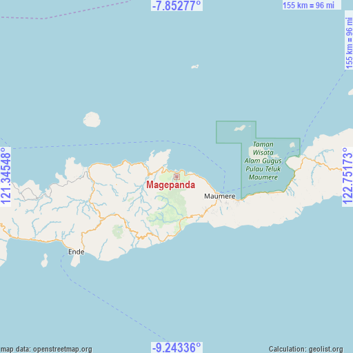
Magepanda GPS coordinates[2]
8° 32' 55.32" South, 122° 2' 54.96" East
| Map corner | latitude | longitude |
|---|---|---|
| Upper-left | -7.85277°, | 121.34548° |
| Center: | -8.5487°, | 122.0486° |
| Lower-right: | -9.24336°, | 122.75173° |
| Map W x H: | 154.6×154.6 km | = 96.1×96.1mi |
| max Lat: | 5.88969° ⇑85.2% North |
| Magepanda: | -8.5487° |
| min Lat: | ⇓14.8% South -10.934° |
| min Long | Magepanda | max Long |
| 95.1345° | 122.0486° | 140.9419° |
| W 88.2%⇐ | ⇒11.8% E |
Elevation
Elevation of Magepanda is 28 m = 92 ft, and this is 201.7 m = 662 ft below average elevation for this country.
| Max E: |
3185 m = 10449 ft | 72.7% |
| Avg. | 229.7 m = 754 ft | |
| Magepanda | 28 m = 92 ft | |
Min E: |
-1 m = -3 ft | 27.3% |
See also: Indonesia elevation on elevation.city.
Geographical zone
Magepanda is located in South Torrid zone (between Equator and Tropic of Capricorn). Distance of Equator is 950.5 km =590.6 mi to North.| Distance of | km | miles | from Magepanda |
|---|---|---|---|
| Equator | 950.5 | 590.6 | to North |
| Tropic Capricorn | 1655.4 | 1028.6 | to South |
| Antarctic Circle | 6450.6 | 4008.2 | to South |
| South Pole | 9056.5 | 5627.4 | to South |


Nearby cities:
15 places around Magepanda: (largest is in red/bold)
• Detuleda
11.7 km =7.3 mi,  182°
182°
• Feondari
13.4 km =8.3 mi,  187°
187°
• Funga
14.9 km =9.3 mi,  206°
206°
• Kotabaru
7.6 km =4.7 mi,  303°
303°
• Loboniki
13.9 km =8.6 mi,  286°
286°
• Lokolande
8.8 km =5.5 mi, 286°
• Nangahure
13.1 km =8.1 mi,  100°
100°
• Nangahurebukitpermai
12.2 km =7.6 mi, 97°
• Niopanda
15.9 km =9.9 mi,  268°
268°
• Nirangkliung
12.8 km =8 mi,  157°
157°
• Retenggoma
13.2 km =8.2 mi,  170°
170°
• Riit
14.7 km =9.1 mi,  143°
143°
• Sokonaja
11.6 km =7.2 mi,  245°
245°
• Urungpigang
16.5 km =10.3 mi,  111°
111°
• Woloau
10.8 km =6.7 mi,  199°
199°
Sources, notices
• [Note1] Compared only with cities in Indonesia existing in our database
• [Src1] Map data: © OpenStreetMap contributors (CC-BY-SA)
• [Src2] Other city data from geonames.org with taken over terms of usage.
• [Src3] Geographical zone / Annual Mean Temperature by Robert A. Rohde @ Wikipedia
