Rutojawa geodata
Rutojawa (East Nusa Tenggara) is a seat of a fourth-order administrative division; located in Indonesia in Asia/Makassar (GMT+8) time zone. In our database, there are 407 cities with bigger population. Compared to other cities in Indonesia, 92.5% of cities are located further ↑North; 85.6% of cities are located further ←West and 92% of cities have lower elevation than Rutojawa. Note1


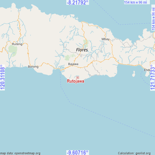
Rutojawa GPS coordinates[2]
8° 54' 47.52" South, 121° 0' 51.12" East
| Map corner | latitude | longitude |
|---|---|---|
| Upper-left | -8.21792°, | 120.31108° |
| Center: | -8.9132°, | 121.0142° |
| Lower-right: | -9.60716°, | 121.71733° |
| Map W x H: | 154.5×154.5 km | = 96×96mi |
| max Lat: | 5.88969° ⇑92.5% North |
| Rutojawa: | -8.9132° |
| min Lat: | ⇓7.5% South -10.934° |
| min Long | Rutojawa | max Long |
| 95.1345° | 121.0142° | 140.9419° |
| W 85.6%⇐ | ⇒14.4% E |
Elevation
Elevation of Rutojawa is 710 m = 2329 ft, and this is 480.3 m = 1576 ft above average elevation for this country.
| Max E: |
3185 m = 10449 ft | 8% |
| Rutojawa | 710 m 2329 ft | |
| Avg. | 229.7 m = 754 ft | |
Min E: |
-1 m = -3 ft | 92% |
See also: Indonesia elevation on elevation.city.
Geographical zone
Rutojawa is located in South Torrid zone (between Equator and Tropic of Capricorn). Distance of Equator is 991.1 km =615.8 mi to North.| Distance of | km | miles | from Rutojawa |
|---|---|---|---|
| Equator | 991.1 | 615.8 | to North |
| Tropic Capricorn | 1614.9 | 1003.5 | to South |
| Antarctic Circle | 6410.1 | 3983.1 | to South |
| South Pole | 9016 | 5602.3 | to South |


Nearby cities:
15 places around Rutojawa: (largest is in red/bold)
• Doka
8.2 km =5.1 mi,  32°
32°
• Dona
1.8 km =1.1 mi,  43°
43°
• Gurusina
3.2 km =2 mi,  305°
305°
• Jadho
8.8 km =5.5 mi, 27°
• Malabhaga
3.4 km =2.1 mi,  343°
343°
• Ngedhubasa
6.1 km =3.8 mi,  125°
125°
• Ngedhusuba
5 km =3.1 mi,  156°
156°
• Nuamuzi
6.3 km =3.9 mi,  357°
357°
• Ranisoba
10 km =6.2 mi,  3°
3°
• Ruto
9.8 km =6.1 mi,  262°
262°
• Sobo
10 km =6.2 mi,  5°
5°
• Waebela
5.6 km =3.5 mi,  234°
234°
• Warekeo
7.6 km =4.7 mi, 357°
• Waturoka
9.1 km =5.7 mi,  59°
59°
• Were
6.8 km =4.2 mi,  48°
48°
Sources, notices
• [Note1] Compared only with cities in Indonesia existing in our database
• [Src1] Map data: © OpenStreetMap contributors (CC-BY-SA)
• [Src2] Other city data from geonames.org with taken over terms of usage.
• [Src3] Geographical zone / Annual Mean Temperature by Robert A. Rohde @ Wikipedia
