Lintek geodata
Lintek (West Nusa Tenggara) is a seat of a fourth-order administrative division; located in Indonesia in Asia/Makassar (GMT+8) time zone. In our database, there are 407 cities with bigger population. Compared to other cities in Indonesia, 88.5% of cities are located further ↑North; 77.3% of cities are located further ←West and 67% of cities have lower elevation than Lintek. Note1


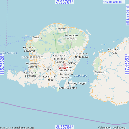
Lintek GPS coordinates[2]
8° 39' 48.24" South, 116° 27' 23.04" East
| Map corner | latitude | longitude |
|---|---|---|
| Upper-left | -7.96767°, | 115.75328° |
| Center: | -8.6634°, | 116.4564° |
| Lower-right: | -9.35784°, | 117.15953° |
| Map W x H: | 154.6×154.6 km | = 96.1×96.1mi |
| max Lat: | 5.88969° ⇑88.5% North |
| Lintek: | -8.6634° |
| min Lat: | ⇓11.5% South -10.934° |
| min Long | Lintek | max Long |
| 95.1345° | 116.4564° | 140.9419° |
| W 77.3%⇐ | ⇒22.7% E |
Elevation
Elevation of Lintek is 251 m = 823 ft, and this is 21.3 m = 70 ft above average elevation for this country.
| Max E: |
3185 m = 10449 ft | 33% |
| Lintek | 251 m 823 ft | |
| Avg. | 229.7 m = 754 ft | |
Min E: |
-1 m = -3 ft | 67% |
See also: Indonesia elevation on elevation.city.
Geographical zone
Lintek is located in South Torrid zone (between Equator and Tropic of Capricorn). Distance of Equator is 963.3 km =598.6 mi to North.| Distance of | km | miles | from Lintek |
|---|---|---|---|
| Equator | 963.3 | 598.6 | to North |
| Tropic Capricorn | 1642.6 | 1020.7 | to South |
| Antarctic Circle | 6437.9 | 4000.3 | to South |
| South Pole | 9043.8 | 5619.6 | to South |


Nearby cities:
15 places around Lintek: (largest is in red/bold)
• Dalam Daya
2.4 km =1.5 mi,  140°
140°
• Gubuk Lauk
3.5 km =2.2 mi,  350°
350°
• Gunungrajak
4.9 km =3 mi,  171°
171°
• Kabar Utara
2.1 km =1.3 mi,  83°
83°
• Laukrurung
3.4 km =2.1 mi,  38°
38°
• Montongbaan
4.3 km =2.7 mi,  313°
313°
• Montongtangi Timuk
5 km =3.1 mi,  121°
121°
• Pancoran
3.4 km =2.1 mi,  90°
90°
• Paokmotong Utara
4.2 km =2.6 mi,  3°
3°
• Sakra
2.3 km =1.4 mi,  164°
164°
• Setanggor
2.9 km =1.8 mi,  68°
68°
• Sikur
3.5 km =2.2 mi,  341°
341°
• Suradi Selatan
4.6 km =2.9 mi,  284°
284°
• Suwangi Utara
3.6 km =2.2 mi,  201°
201°
• Timba Lauk
4.9 km =3 mi, 344°
Sources, notices
• [Note1] Compared only with cities in Indonesia existing in our database
• [Src1] Map data: © OpenStreetMap contributors (CC-BY-SA)
• [Src2] Other city data from geonames.org with taken over terms of usage.
• [Src3] Geographical zone / Annual Mean Temperature by Robert A. Rohde @ Wikipedia
