Wongka geodata
Wongka (East Nusa Tenggara) is a seat of a fourth-order administrative division; located in Indonesia in Asia/Makassar (GMT+8) time zone. In our database, there are 407 cities with bigger population. Compared to other cities in Indonesia, 91.6% of cities are located further ↑North; 83.7% of cities are located further ←West and 81% of cities have lower elevation than Wongka. Note1


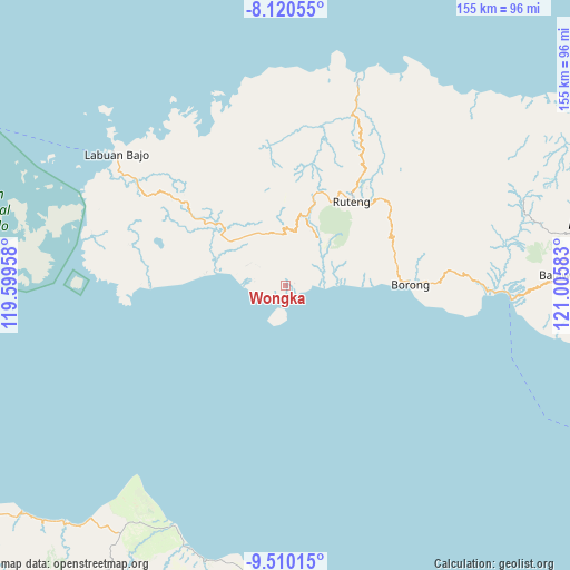
Wongka GPS coordinates[2]
8° 48' 57.6" South, 120° 18' 9.72" East
| Map corner | latitude | longitude |
|---|---|---|
| Upper-left | -8.12055°, | 119.59958° |
| Center: | -8.816°, | 120.3027° |
| Lower-right: | -9.51015°, | 121.00583° |
| Map W x H: | 154.5×154.5 km | = 96×96mi |
| max Lat: | 5.88969° ⇑91.6% North |
| Wongka: | -8.816° |
| min Lat: | ⇓8.4% South -10.934° |
| min Long | Wongka | max Long |
| 95.1345° | 120.3027° | 140.9419° |
| W 83.7%⇐ | ⇒16.3% E |
Elevation
Elevation of Wongka is 447 m = 1467 ft, and this is 217.3 m = 713 ft above average elevation for this country.
| Max E: |
3185 m = 10449 ft | 19% |
| Wongka | 447 m 1467 ft | |
| Avg. | 229.7 m = 754 ft | |
Min E: |
-1 m = -3 ft | 81% |
See also: Indonesia elevation on elevation.city.
Geographical zone
Wongka is located in South Torrid zone (between Equator and Tropic of Capricorn). Distance of Equator is 980.2 km =609.1 mi to North.| Distance of | km | miles | from Wongka |
|---|---|---|---|
| Equator | 980.2 | 609.1 | to North |
| Tropic Capricorn | 1625.7 | 1010.2 | to South |
| Antarctic Circle | 6420.9 | 3989.8 | to South |
| South Pole | 9026.8 | 5609 | to South |


Nearby cities:
15 places around Wongka: (largest is in red/bold)
• Benteng
7.3 km =4.5 mi,  90°
90°
• Borik
6.6 km =4.1 mi,  242°
242°
• Iteng
13.1 km =8.1 mi, 88°
• Kaca
11 km =6.8 mi,  311°
311°
• Keka
5.2 km =3.2 mi,  95°
95°
• Lamba
14.5 km =9 mi, 85°
• Nangalili
19.4 km =12.1 mi,  283°
283°
• Narang
8.5 km =5.3 mi,  59°
59°
• Paka
13.4 km =8.3 mi,  72°
72°
• Ponggeok
16.1 km =10 mi,  49°
49°
• Pongkor
14.7 km =9.1 mi,  39°
39°
• Pora
14.9 km =9.3 mi, 36°
• Waepau
8.5 km =5.3 mi, 277°
• Watuweri
18.8 km =11.7 mi,  79°
79°
• Woa
21.7 km =13.5 mi, 84°
Sources, notices
• [Note1] Compared only with cities in Indonesia existing in our database
• [Src1] Map data: © OpenStreetMap contributors (CC-BY-SA)
• [Src2] Other city data from geonames.org with taken over terms of usage.
• [Src3] Geographical zone / Annual Mean Temperature by Robert A. Rohde @ Wikipedia
