Narang geodata
Narang (East Nusa Tenggara) is a seat of a fourth-order administrative division; located in Indonesia in Asia/Makassar (GMT+8) time zone. In our database, there are 407 cities with bigger population. Compared to other cities in Indonesia, 91% of cities are located further ↑North; 83.9% of cities are located further ←West and 76.2% of cities have lower elevation than Narang. Note1


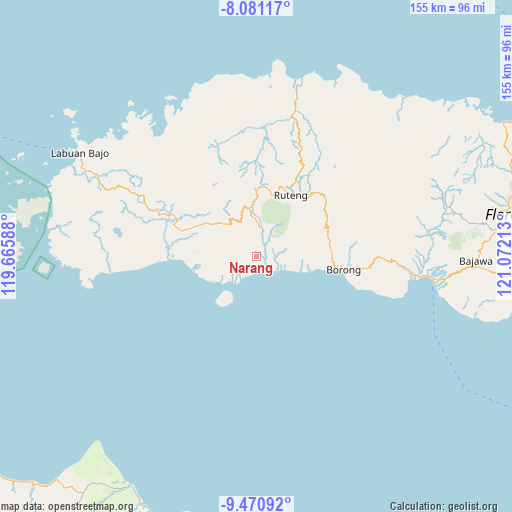
Narang GPS coordinates[2]
8° 46' 36.12" South, 120° 22' 8.4" East
| Map corner | latitude | longitude |
|---|---|---|
| Upper-left | -8.08117°, | 119.66588° |
| Center: | -8.7767°, | 120.369° |
| Lower-right: | -9.47092°, | 121.07213° |
| Map W x H: | 154.5×154.5 km | = 96×96mi |
| max Lat: | 5.88969° ⇑91% North |
| Narang: | -8.7767° |
| min Lat: | ⇓9% South -10.934° |
| min Long | Narang | max Long |
| 95.1345° | 120.369° | 140.9419° |
| W 83.9%⇐ | ⇒16.1% E |
Elevation
Elevation of Narang is 375 m = 1230 ft, and this is 145.3 m = 477 ft above average elevation for this country.
| Max E: |
3185 m = 10449 ft | 23.8% |
| Narang | 375 m 1230 ft | |
| Avg. | 229.7 m = 754 ft | |
Min E: |
-1 m = -3 ft | 76.2% |
See also: Indonesia elevation on elevation.city.
Geographical zone
Narang is located in South Torrid zone (between Equator and Tropic of Capricorn). Distance of Equator is 975.9 km =606.4 mi to North.| Distance of | km | miles | from Narang |
|---|---|---|---|
| Equator | 975.9 | 606.4 | to North |
| Tropic Capricorn | 1630 | 1012.8 | to South |
| Antarctic Circle | 6425.3 | 3992.5 | to South |
| South Pole | 9031.2 | 5611.7 | to South |


Nearby cities:
15 places around Narang: (largest is in red/bold)
• Benteng
4.4 km =2.7 mi,  179°
179°
• Bombu
18.8 km =11.7 mi,  59°
59°
• Borik
15.1 km =9.4 mi,  240°
240°
• Iteng
7 km =4.3 mi,  124°
124°
• Kaca
15.8 km =9.8 mi,  280°
280°
• Keka
5.3 km =3.3 mi,  203°
203°
• Lamba
7.9 km =4.9 mi,  114°
114°
• Paka
5.5 km =3.4 mi,  93°
93°
• Ponggeok
7.8 km =4.8 mi,  39°
39°
• Pongkor
7.3 km =4.5 mi,  16°
16°
• Pora
7.7 km =4.8 mi,  12°
12°
• Waepau
16.1 km =10 mi,  258°
258°
• Watuweri
11.2 km =7 mi, 94°
• Woa
14.5 km =9 mi,  99°
99°
• Wongka
8.5 km =5.3 mi, 239°
Sources, notices
• [Note1] Compared only with cities in Indonesia existing in our database
• [Src1] Map data: © OpenStreetMap contributors (CC-BY-SA)
• [Src2] Other city data from geonames.org with taken over terms of usage.
• [Src3] Geographical zone / Annual Mean Temperature by Robert A. Rohde @ Wikipedia
