Montongkemong geodata
Montongkemong (West Nusa Tenggara) is a seat of a fourth-order administrative division; located in Indonesia in Asia/Makassar (GMT+8) time zone. In our database, there are 407 cities with bigger population. Compared to other cities in Indonesia, 83.1% of cities are located further ↑North; 77.8% of cities are located further ←West and 90.4% of cities have lower elevation than Montongkemong. Note1


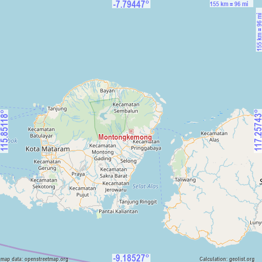
Montongkemong GPS coordinates[2]
8° 29' 25.8" South, 116° 33' 15.48" East
| Map corner | latitude | longitude |
|---|---|---|
| Upper-left | -7.79447°, | 115.85118° |
| Center: | -8.4905°, | 116.5543° |
| Lower-right: | -9.18527°, | 117.25743° |
| Map W x H: | 154.6×154.6 km | = 96.1×96.1mi |
| max Lat: | 5.88969° ⇑83.1% North |
| Montongkemong: | -8.4905° |
| min Lat: | ⇓16.9% South -10.934° |
| min Long | Montongkemong | max Long |
| 95.1345° | 116.5543° | 140.9419° |
| W 77.8%⇐ | ⇒22.2% E |
Elevation
Elevation of Montongkemong is 655 m = 2149 ft, and this is 425.3 m = 1395 ft above average elevation for this country.
| Max E: |
3185 m = 10449 ft | 9.6% |
| Montongkemong | 655 m 2149 ft | |
| Avg. | 229.7 m = 754 ft | |
Min E: |
-1 m = -3 ft | 90.4% |
See also: Indonesia elevation on elevation.city.
Geographical zone
Montongkemong is located in South Torrid zone (between Equator and Tropic of Capricorn). Distance of Equator is 944.1 km =586.6 mi to North.| Distance of | km | miles | from Montongkemong |
|---|---|---|---|
| Equator | 944.1 | 586.6 | to North |
| Tropic Capricorn | 1661.9 | 1032.7 | to South |
| Antarctic Circle | 6457.1 | 4012.3 | to South |
| South Pole | 9063 | 5631.5 | to South |


Nearby cities:
15 places around Montongkemong: (largest is in red/bold)
• Aikmel
9 km =5.6 mi,  196°
196°
• Bagikkedok Lauk
10.7 km =6.6 mi,  147°
147°
• Batubasong Lauk
5.2 km =3.2 mi,  142°
142°
• Dasanlian Lauk
7.8 km =4.8 mi,  209°
209°
• Gubuk Daya
4.3 km =2.7 mi, 151°
• Gubuk Daya
11.7 km =7.3 mi, 138°
• Gubukjero Timuk
11.3 km =7 mi,  226°
226°
• Jorong Lauk
8.8 km =5.5 mi,  164°
164°
• Karangranjong
11.2 km =7 mi, 204°
• Kembangkerang Lauk Timur
7.8 km =4.8 mi,  193°
193°
• Keroak
10.8 km =6.7 mi, 214°
• Montonggedeng
6.8 km =4.2 mi, 142°
• Pringgabaya
11.3 km =7 mi,  130°
130°
• Selaparang Timur
8.2 km =5.1 mi, 141°
• Sembalunbumbung
11.8 km =7.3 mi,  354°
354°
Sources, notices
• [Note1] Compared only with cities in Indonesia existing in our database
• [Src1] Map data: © OpenStreetMap contributors (CC-BY-SA)
• [Src2] Other city data from geonames.org with taken over terms of usage.
• [Src3] Geographical zone / Annual Mean Temperature by Robert A. Rohde @ Wikipedia
