Gubuk Daya geodata
Gubuk Daya (West Nusa Tenggara) is a seat of a fourth-order administrative division; located in Indonesia in Asia/Makassar (GMT+8) time zone. In our database, there are 407 cities with bigger population. Compared to other cities in Indonesia, 84.4% of cities are located further ↑North; 77.9% of cities are located further ←West and 75% of cities have lower elevation than Gubuk Daya. Note1


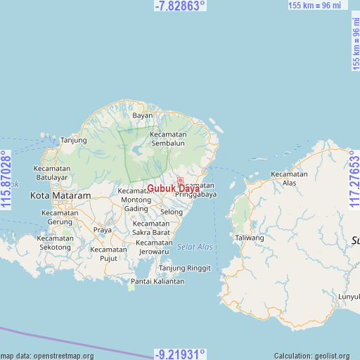
Gubuk Daya GPS coordinates[2]
8° 31' 28.56" South, 116° 34' 24.24" East
| Map corner | latitude | longitude |
|---|---|---|
| Upper-left | -7.82863°, | 115.87028° |
| Center: | -8.5246°, | 116.5734° |
| Lower-right: | -9.21931°, | 117.27653° |
| Map W x H: | 154.6×154.6 km | = 96.1×96.1mi |
| max Lat: | 5.88969° ⇑84.4% North |
| Gubuk Daya: | -8.5246° |
| min Lat: | ⇓15.6% South -10.934° |
| min Long | Gubuk Daya | max Long |
| 95.1345° | 116.5734° | 140.9419° |
| W 77.9%⇐ | ⇒22.1% E |
Elevation
Elevation of Gubuk Daya is 359 m = 1178 ft, and this is 129.3 m = 424 ft above average elevation for this country.
| Max E: |
3185 m = 10449 ft | 25% |
| Gubuk Daya | 359 m 1178 ft | |
| Avg. | 229.7 m = 754 ft | |
Min E: |
-1 m = -3 ft | 75% |
See also: Indonesia elevation on elevation.city.
Geographical zone
Gubuk Daya is located in South Torrid zone (between Equator and Tropic of Capricorn). Distance of Equator is 947.8 km =588.9 mi to North.| Distance of | km | miles | from Gubuk Daya |
|---|---|---|---|
| Equator | 947.8 | 588.9 | to North |
| Tropic Capricorn | 1658.1 | 1030.3 | to South |
| Antarctic Circle | 6453.3 | 4009.9 | to South |
| South Pole | 9059.2 | 5629.1 | to South |


Nearby cities:
15 places around Gubuk Daya: (largest is in red/bold)
• Aikmel
6.7 km =4.2 mi,  224°
224°
• Bagikkedok Lauk
6.4 km =4 mi,  145°
145°
• Batubasong Lauk
1.1 km =0.7 mi,  107°
107°
• Dasanlian Lauk
6.7 km =4.2 mi,  243°
243°
• Gelumpang
9.6 km =6 mi,  213°
213°
• Gubuk Daya
7.5 km =4.7 mi,  131°
131°
• Jorong Lauk
4.7 km =2.9 mi,  177°
177°
• Kampungbaru
10.3 km =6.4 mi,  75°
75°
• Karangranjong
9.3 km =5.8 mi,  226°
226°
• Kembangkerang Lauk Timur
5.4 km =3.4 mi, 226°
• Keroak
9.7 km =6 mi, 238°
• Montonggedeng
2.6 km =1.6 mi, 128°
• Montongkemong
4.3 km =2.7 mi,  331°
331°
• Pringgabaya
7.4 km =4.6 mi,  119°
119°
• Selaparang Timur
4 km =2.5 mi, 130°
Sources, notices
• [Note1] Compared only with cities in Indonesia existing in our database
• [Src1] Map data: © OpenStreetMap contributors (CC-BY-SA)
• [Src2] Other city data from geonames.org with taken over terms of usage.
• [Src3] Geographical zone / Annual Mean Temperature by Robert A. Rohde @ Wikipedia
