Doya geodata
Doya (East Nusa Tenggara) is a seat of a fourth-order administrative division; located in Indonesia in Asia/Makassar (GMT+8) time zone. In our database, there are 407 cities with bigger population. Compared to other cities in Indonesia, 91.8% of cities are located further ↑North; 86% of cities are located further ←West and 93.9% of cities have lower elevation than Doya. Note1


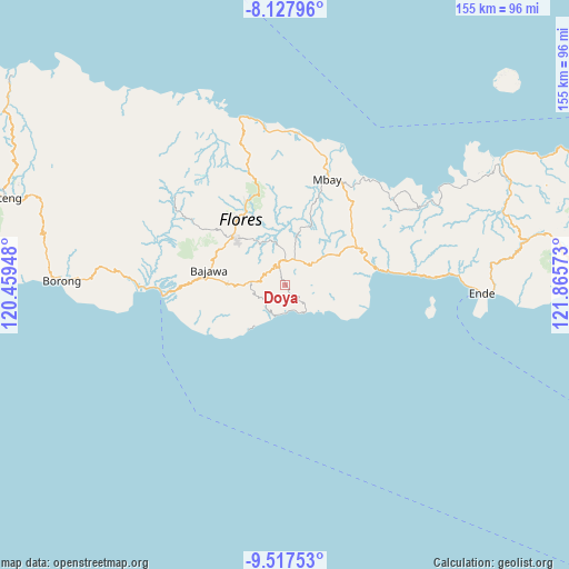
Doya GPS coordinates[2]
8° 49' 24.24" South, 121° 9' 45.36" East
| Map corner | latitude | longitude |
|---|---|---|
| Upper-left | -8.12796°, | 120.45948° |
| Center: | -8.8234°, | 121.1626° |
| Lower-right: | -9.51753°, | 121.86573° |
| Map W x H: | 154.5×154.5 km | = 96×96mi |
| max Lat: | 5.88969° ⇑91.8% North |
| Doya: | -8.8234° |
| min Lat: | ⇓8.2% South -10.934° |
| min Long | Doya | max Long |
| 95.1345° | 121.1626° | 140.9419° |
| W 86%⇐ | ⇒14% E |
Elevation
Elevation of Doya is 763 m = 2503 ft, and this is 533.3 m = 1750 ft above average elevation for this country.
| Max E: |
3185 m = 10449 ft | 6.1% |
| Doya | 763 m 2503 ft | |
| Avg. | 229.7 m = 754 ft | |
Min E: |
-1 m = -3 ft | 93.9% |
See also: Indonesia elevation on elevation.city.
Geographical zone
Doya is located in South Torrid zone (between Equator and Tropic of Capricorn). Distance of Equator is 981.1 km =609.6 mi to North.| Distance of | km | miles | from Doya |
|---|---|---|---|
| Equator | 981.1 | 609.6 | to North |
| Tropic Capricorn | 1624.8 | 1009.6 | to South |
| Antarctic Circle | 6420.1 | 3989.3 | to South |
| South Pole | 9026 | 5608.5 | to South |


Nearby cities:
15 places around Doya: (largest is in red/bold)
• Boawae
6.7 km =4.2 mi,  6°
6°
• Dawe
5.1 km =3.2 mi,  118°
118°
• Gelu
6.8 km =4.2 mi, 116°
• Hobonio
5.8 km =3.6 mi,  315°
315°
• Laja
7.4 km =4.6 mi,  242°
242°
• Lokawolo
5.6 km =3.5 mi,  110°
110°
• Mulakoli
6.4 km =4 mi,  70°
70°
• Nunukae
2.7 km =1.7 mi,  336°
336°
• Padhahegha
6.2 km =3.9 mi,  333°
333°
• Pajoreja
4.3 km =2.7 mi, 123°
• Pogo
6.7 km =4.2 mi,  297°
297°
• Sukamaju
5 km =3.1 mi,  137°
137°
• Taka
5.7 km =3.5 mi,  250°
250°
• Wagha
5 km =3.1 mi,  184°
184°
• Wudu
7.1 km =4.4 mi,  39°
39°
Sources, notices
• [Note1] Compared only with cities in Indonesia existing in our database
• [Src1] Map data: © OpenStreetMap contributors (CC-BY-SA)
• [Src2] Other city data from geonames.org with taken over terms of usage.
• [Src3] Geographical zone / Annual Mean Temperature by Robert A. Rohde @ Wikipedia
