Sentulan geodata
Sentulan (East Java) is a seat of a fourth-order administrative division; located in Indonesia in Asia/Jakarta (GMT+7) time zone. In our database, there are 407 cities with bigger population. Compared to other cities in Indonesia, 63.7% of cities are located further ↑North; 51.6% of cities are located further →East and 53.4% of cities have higher elevation than Sentulan. Note1


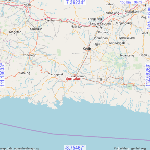
Sentulan GPS coordinates[2]
8° 3' 32.76" South, 111° 53' 22.2" East
| Map corner | latitude | longitude |
|---|---|---|
| Upper-left | -7.36234°, | 111.18638° |
| Center: | -8.0591°, | 111.8895° |
| Lower-right: | -8.75467°, | 112.59263° |
| Map W x H: | 154.8×154.8 km | = 96.2×96.2mi |
| max Lat: | 5.88969° ⇑63.7% North |
| Sentulan: | -8.0591° |
| min Lat: | ⇓36.3% South -10.934° |
| min Long | Sentulan | max Long |
| 95.1345° | 111.8895° | 140.9419° |
| W 48.4%⇐ | ⇒51.6% E |
Elevation
Elevation of Sentulan is 91 m = 299 ft, and this is 138.7 m = 455 ft below average elevation for this country.
| Max E: |
3185 m = 10449 ft | 53.4% |
| Avg. | 229.7 m = 754 ft | |
| Sentulan | 91 m = 299 ft | |
Min E: |
-1 m = -3 ft | 46.6% |
See also: Indonesia elevation on elevation.city.
Geographical zone
Sentulan is located in South Torrid zone (between Equator and Tropic of Capricorn). Distance of Equator is 896.1 km =556.8 mi to North.| Distance of | km | miles | from Sentulan |
|---|---|---|---|
| Equator | 896.1 | 556.8 | to North |
| Tropic Capricorn | 1709.8 | 1062.4 | to South |
| Antarctic Circle | 6505.1 | 4042.1 | to South |
| South Pole | 9111 | 5661.3 | to South |


Nearby cities:
15 places around Sentulan: (largest is in red/bold)
• Batangsaren
1.1 km =0.7 mi,  301°
301°
• Bebekan
1.9 km =1.2 mi,  263°
263°
• Gedangsewu Selatan
1.9 km =1.2 mi,  180°
180°
• Irongganan
2.2 km =1.4 mi, 295°
• Kanugrahan
1.5 km =0.9 mi,  48°
48°
• Karangwaru
1.6 km =1 mi,  141°
141°
• Kauman
1 km =0.6 mi,  130°
130°
• Kutoanyar
1 km =0.6 mi, 176°
• Pacet
2.3 km =1.4 mi,  201°
201°
• Prayan
2.3 km =1.4 mi,  164°
164°
• Sembung
0.7 km =0.4 mi,  107°
107°
• Tamanan
2 km =1.2 mi, 135°
• Tertek
1.3 km =0.8 mi,  168°
168°
• Tulungagung
1.6 km =1 mi,  117°
117°
• Winong
2 km =1.2 mi,  35°
35°
Sources, notices
• [Note1] Compared only with cities in Indonesia existing in our database
• [Src1] Map data: © OpenStreetMap contributors (CC-BY-SA)
• [Src2] Other city data from geonames.org with taken over terms of usage.
• [Src3] Geographical zone / Annual Mean Temperature by Robert A. Rohde @ Wikipedia
