Kauman geodata
Kauman (East Java) is a seat of a fourth-order administrative division; located in Indonesia in Asia/Jakarta (GMT+7) time zone. In our database, there are 407 cities with bigger population. Compared to other cities in Indonesia, 64% of cities are located further ↑North; 51.4% of cities are located further →East and 53% of cities have higher elevation than Kauman. Note1


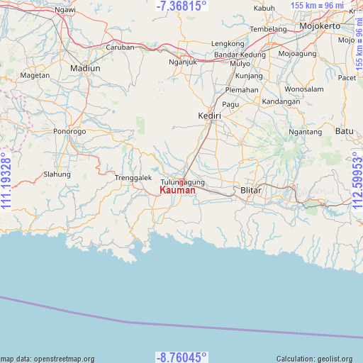
Kauman GPS coordinates[2]
8° 3' 53.64" South, 111° 53' 47.04" East
| Map corner | latitude | longitude |
|---|---|---|
| Upper-left | -7.36815°, | 111.19328° |
| Center: | -8.0649°, | 111.8964° |
| Lower-right: | -8.76045°, | 112.59953° |
| Map W x H: | 154.8×154.8 km | = 96.2×96.2mi |
| max Lat: | 5.88969° ⇑64% North |
| Kauman: | -8.0649° |
| min Lat: | ⇓36% South -10.934° |
| min Long | Kauman | max Long |
| 95.1345° | 111.8964° | 140.9419° |
| W 48.6%⇐ | ⇒51.4% E |
Elevation
Elevation of Kauman is 92 m = 302 ft, and this is 137.7 m = 452 ft below average elevation for this country.
| Max E: |
3185 m = 10449 ft | 53% |
| Avg. | 229.7 m = 754 ft | |
| Kauman | 92 m = 302 ft | |
Min E: |
-1 m = -3 ft | 47% |
See also: Indonesia elevation on elevation.city.
Geographical zone
Kauman is located in South Torrid zone (between Equator and Tropic of Capricorn). Distance of Equator is 896.7 km =557.2 mi to North.| Distance of | km | miles | from Kauman |
|---|---|---|---|
| Equator | 896.7 | 557.2 | to North |
| Tropic Capricorn | 1709.2 | 1062 | to South |
| Antarctic Circle | 6504.4 | 4041.6 | to South |
| South Pole | 9110.3 | 5660.9 | to South |


Nearby cities:
15 places around Kauman: (largest is in red/bold)
• Bago
1.5 km =0.9 mi,  105°
105°
• Batangsaren
2.1 km =1.3 mi,  305°
305°
• Gedangsewu Selatan
1.4 km =0.9 mi,  212°
212°
• Jepun
2 km =1.2 mi,  126°
126°
• Kanugrahan
1.7 km =1.1 mi,  11°
11°
• Karangwaru
0.6 km =0.4 mi,  159°
159°
• Kedungtaman
2 km =1.2 mi,  55°
55°
• Kepatihan
1.9 km =1.2 mi,  83°
83°
• Kutoanyar
0.8 km =0.5 mi,  246°
246°
• Prayan
1.6 km =1 mi,  185°
185°
• Sembung
0.4 km =0.2 mi,  349°
349°
• Sentulan
1 km =0.6 mi, 310°
• Tamanan
1.1 km =0.7 mi,  139°
139°
• Tertek
0.8 km =0.5 mi,  219°
219°
• Tulungagung
0.7 km =0.4 mi,  97°
97°
Sources, notices
• [Note1] Compared only with cities in Indonesia existing in our database
• [Src1] Map data: © OpenStreetMap contributors (CC-BY-SA)
• [Src2] Other city data from geonames.org with taken over terms of usage.
• [Src3] Geographical zone / Annual Mean Temperature by Robert A. Rohde @ Wikipedia
