Sembung geodata
Sembung (East Java) is a seat of a fourth-order administrative division; located in Indonesia in Asia/Jakarta (GMT+7) time zone. In our database, there are 407 cities with bigger population. Compared to other cities in Indonesia, 63.8% of cities are located further ↑North; 51.5% of cities are located further →East and 54% of cities have higher elevation than Sembung. Note1


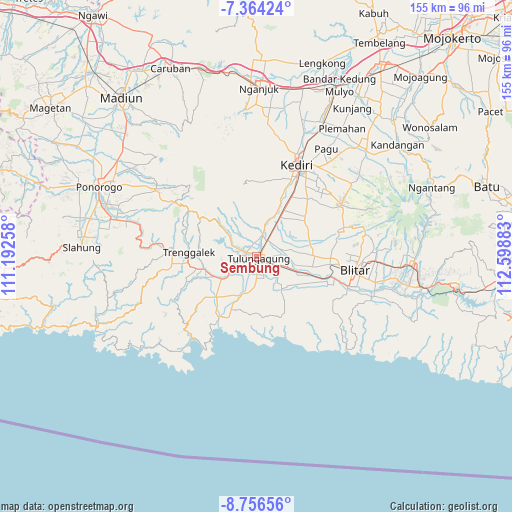
Sembung GPS coordinates[2]
8° 3' 39.6" South, 111° 53' 44.52" East
| Map corner | latitude | longitude |
|---|---|---|
| Upper-left | -7.36424°, | 111.19258° |
| Center: | -8.061°, | 111.8957° |
| Lower-right: | -8.75656°, | 112.59883° |
| Map W x H: | 154.8×154.8 km | = 96.2×96.2mi |
| max Lat: | 5.88969° ⇑63.8% North |
| Sembung: | -8.061° |
| min Lat: | ⇓36.2% South -10.934° |
| min Long | Sembung | max Long |
| 95.1345° | 111.8957° | 140.9419° |
| W 48.5%⇐ | ⇒51.5% E |
Elevation
Elevation of Sembung is 89 m = 292 ft, and this is 140.7 m = 462 ft below average elevation for this country.
| Max E: |
3185 m = 10449 ft | 54% |
| Avg. | 229.7 m = 754 ft | |
| Sembung | 89 m = 292 ft | |
Min E: |
-1 m = -3 ft | 46% |
See also: Indonesia elevation on elevation.city.
Geographical zone
Sembung is located in South Torrid zone (between Equator and Tropic of Capricorn). Distance of Equator is 896.3 km =556.9 mi to North.| Distance of | km | miles | from Sembung |
|---|---|---|---|
| Equator | 896.3 | 556.9 | to North |
| Tropic Capricorn | 1709.6 | 1062.3 | to South |
| Antarctic Circle | 6504.9 | 4042 | to South |
| South Pole | 9110.8 | 5661.2 | to South |


Nearby cities:
15 places around Sembung: (largest is in red/bold)
• Bago
1.7 km =1.1 mi,  119°
119°
• Batangsaren
1.8 km =1.1 mi,  295°
295°
• Gedangsewu Selatan
1.8 km =1.1 mi,  202°
202°
• Kanugrahan
1.3 km =0.8 mi,  19°
19°
• Karangwaru
1.1 km =0.7 mi,  163°
163°
• Kauman
0.4 km =0.2 mi,  169°
169°
• Kedungtaman
1.9 km =1.2 mi,  67°
67°
• Kepatihan
1.9 km =1.2 mi,  96°
96°
• Kutoanyar
1 km =0.6 mi,  220°
220°
• Prayan
2 km =1.2 mi,  181°
181°
• Sentulan
0.7 km =0.4 mi,  287°
287°
• Tamanan
1.5 km =0.9 mi,  148°
148°
• Tertek
1.1 km =0.7 mi, 201°
• Tulungagung
0.9 km =0.6 mi, 124°
• Winong
1.9 km =1.2 mi, 15°
Sources, notices
• [Note1] Compared only with cities in Indonesia existing in our database
• [Src1] Map data: © OpenStreetMap contributors (CC-BY-SA)
• [Src2] Other city data from geonames.org with taken over terms of usage.
• [Src3] Geographical zone / Annual Mean Temperature by Robert A. Rohde @ Wikipedia
