Senggapi geodata
Senggapi (East Nusa Tenggara) is a seat of a third-order administrative division; located in Indonesia in Asia/Makassar (GMT+8) time zone. In our database, there are 407 cities with bigger population. Compared to other cities in Indonesia, 76.6% of cities are located further ↑North; 84.1% of cities are located further ←West and 85.2% of cities have higher elevation than Senggapi. Note1


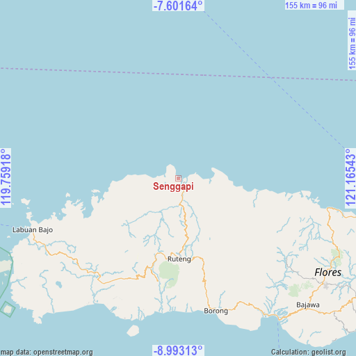
Senggapi GPS coordinates[2]
8° 17' 52.8" South, 120° 27' 44.28" East
| Map corner | latitude | longitude |
|---|---|---|
| Upper-left | -7.60164°, | 119.75918° |
| Center: | -8.298°, | 120.4623° |
| Lower-right: | -8.99313°, | 121.16543° |
| Map W x H: | 154.7×154.7 km | = 96.1×96.1mi |
| max Lat: | 5.88969° ⇑76.6% North |
| Senggapi: | -8.298° |
| min Lat: | ⇓23.4% South -10.934° |
| min Long | Senggapi | max Long |
| 95.1345° | 120.4623° | 140.9419° |
| W 84.1%⇐ | ⇒15.9% E |
Elevation
Elevation of Senggapi is 14 m = 46 ft, and this is 215.7 m = 708 ft below average elevation for this country.
| Max E: |
3185 m = 10449 ft | 85.2% |
| Avg. | 229.7 m = 754 ft | |
| Senggapi | 14 m = 46 ft | |
Min E: |
-1 m = -3 ft | 14.8% |
See also: Indonesia elevation on elevation.city.
Geographical zone
Senggapi is located in South Torrid zone (between Equator and Tropic of Capricorn). Distance of Equator is 922.7 km =573.3 mi to North.| Distance of | km | miles | from Senggapi |
|---|---|---|---|
| Equator | 922.7 | 573.3 | to North |
| Tropic Capricorn | 1683.3 | 1046 | to South |
| Antarctic Circle | 6478.5 | 4025.6 | to South |
| South Pole | 9084.4 | 5644.8 | to South |


Nearby cities:
15 places around Senggapi: (largest is in red/bold)
• Baru
3.3 km =2.1 mi,  107°
107°
• Baru Timur
3.4 km =2.1 mi, 109°
• Congkar
6.2 km =3.9 mi,  289°
289°
• Dampek
14.5 km =9 mi,  91°
91°
• Golopau
15.8 km =9.8 mi,  142°
142°
• Lanos
6.1 km =3.8 mi, 286°
• Pering
7.8 km =4.8 mi,  249°
249°
• Reo
3.2 km =2 mi, 113°
• Ruis
8.1 km =5 mi,  203°
203°
• Satarteu
6.6 km =4.1 mi, 112°
• Sengari
1.2 km =0.7 mi,  324°
324°
• Tanahputih
2.6 km =1.6 mi,  119°
119°
• Wangkung
1.9 km =1.2 mi,  307°
307°
• Weleng
13.7 km =8.5 mi,  150°
150°
• Wontong
10.9 km =6.8 mi,  244°
244°
Sources, notices
• [Note1] Compared only with cities in Indonesia existing in our database
• [Src1] Map data: © OpenStreetMap contributors (CC-BY-SA)
• [Src2] Other city data from geonames.org with taken over terms of usage.
• [Src3] Geographical zone / Annual Mean Temperature by Robert A. Rohde @ Wikipedia
