Wontong geodata
Wontong (East Nusa Tenggara) is a seat of a fourth-order administrative division; located in Indonesia in Asia/Makassar (GMT+8) time zone. In our database, there are 407 cities with bigger population. Compared to other cities in Indonesia, 78.4% of cities are located further ↑North; 83.9% of cities are located further ←West and 77.9% of cities have lower elevation than Wontong. Note1


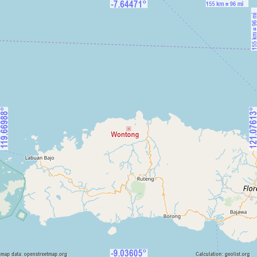
Wontong GPS coordinates[2]
8° 20' 27.6" South, 120° 22' 22.8" East
| Map corner | latitude | longitude |
|---|---|---|
| Upper-left | -7.64471°, | 119.66988° |
| Center: | -8.341°, | 120.373° |
| Lower-right: | -9.03605°, | 121.07613° |
| Map W x H: | 154.7×154.7 km | = 96.1×96.1mi |
| max Lat: | 5.88969° ⇑78.4% North |
| Wontong: | -8.341° |
| min Lat: | ⇓21.6% South -10.934° |
| min Long | Wontong | max Long |
| 95.1345° | 120.373° | 140.9419° |
| W 83.9%⇐ | ⇒16.1% E |
Elevation
Elevation of Wontong is 396 m = 1299 ft, and this is 166.3 m = 546 ft above average elevation for this country.
| Max E: |
3185 m = 10449 ft | 22.1% |
| Wontong | 396 m 1299 ft | |
| Avg. | 229.7 m = 754 ft | |
Min E: |
-1 m = -3 ft | 77.9% |
See also: Indonesia elevation on elevation.city.
Geographical zone
Wontong is located in South Torrid zone (between Equator and Tropic of Capricorn). Distance of Equator is 927.4 km =576.3 mi to North.| Distance of | km | miles | from Wontong |
|---|---|---|---|
| Equator | 927.4 | 576.3 | to North |
| Tropic Capricorn | 1678.5 | 1043 | to South |
| Antarctic Circle | 6473.7 | 4022.6 | to South |
| South Pole | 9079.6 | 5641.8 | to South |


Nearby cities:
15 places around Wontong: (largest is in red/bold)
• Baru
13.5 km =8.4 mi,  73°
73°
• Baru Timur
13.5 km =8.4 mi, 74°
• Congkar
7.9 km =4.9 mi,  30°
30°
• Lanos
7.6 km =4.7 mi, 31°
• Nggalak
6.3 km =3.9 mi,  256°
256°
• Nggilat
14 km =8.7 mi,  285°
285°
• Pering
3.2 km =2 mi,  51°
51°
• Rego
16 km =9.9 mi,  233°
233°
• Reo
13.3 km =8.3 mi, 74°
• Ruis
7.2 km =4.5 mi,  111°
111°
• Satarteu
16.1 km =10 mi,  82°
82°
• Sengari
10.8 km =6.7 mi,  57°
57°
• Senggapi
10.9 km =6.8 mi, 64°
• Tanahputih
12.6 km =7.8 mi, 73°
• Wangkung
10.2 km =6.3 mi, 54°
Sources, notices
• [Note1] Compared only with cities in Indonesia existing in our database
• [Src1] Map data: © OpenStreetMap contributors (CC-BY-SA)
• [Src2] Other city data from geonames.org with taken over terms of usage.
• [Src3] Geographical zone / Annual Mean Temperature by Robert A. Rohde @ Wikipedia
