Pasuruan geodata
Pasuruan (Lampung) is a seat of a third-order administrative division; located in Indonesia in Asia/Jakarta (GMT+7) time zone. In our database, there are 407 cities with bigger population. Compared to other cities in Indonesia, 88.1% of cities are located further ↓South; 94.1% of cities are located further →East and 56.1% of cities have higher elevation than Pasuruan. Note1


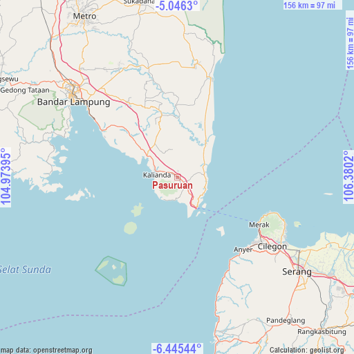
Pasuruan GPS coordinates[2]
5° 44' 46.68" South, 105° 40' 37.452" East
| Map corner | latitude | longitude |
|---|---|---|
| Upper-left | -5.0463°, | 104.97395° |
| Center: | -5.7463°, | 105.67707° |
| Lower-right: | -6.44544°, | 106.3802° |
| Map W x H: | 155.6×155.6 km | = 96.7×96.7mi |
| max Lat: | 5.88969° ⇑11.9% North |
| Pasuruan: | -5.7463° |
| min Lat: | ⇓88.1% South -10.934° |
| min Long | Pasuruan | max Long |
| 95.1345° | 105.67707° | 140.9419° |
| W 5.9%⇐ | ⇒94.1% E |
Elevation
Elevation of Pasuruan is 78 m = 256 ft, and this is 151.7 m = 498 ft below average elevation for this country.
| Max E: |
3185 m = 10449 ft | 56.1% |
| Avg. | 229.7 m = 754 ft | |
| Pasuruan | 78 m = 256 ft | |
Min E: |
-1 m = -3 ft | 43.9% |
See also: Indonesia elevation on elevation.city.
Geographical zone
Pasuruan is located in South Torrid zone (between Equator and Tropic of Capricorn). Distance of Equator is 638.9 km =397 mi to North.| Distance of | km | miles | from Pasuruan |
|---|---|---|---|
| Equator | 638.9 | 397 | to North |
| Tropic Capricorn | 1967 | 1222.2 | to South |
| Antarctic Circle | 6762.2 | 4201.8 | to South |
| South Pole | 9368.1 | 5821.1 | to South |


Nearby cities:
15 places around Pasuruan: (largest is in red/bold)
• Ciparay
47.8 km =29.7 mi,  154°
154°
• Curug
46 km =28.6 mi,  124°
124°
• Jabung
31.5 km =19.6 mi,  358°
358°
• Kalianda
9.5 km =5.9 mi,  275°
275°
• Kopibera
50.3 km =31.3 mi, 154°
• Kubangkepuh
42.4 km =26.3 mi,  113°
113°
• Labuhanmaringgai
46.4 km =28.8 mi,  18°
18°
• Mekarsari
50 km =31.1 mi, 149°
• Pakuncen
49.3 km =30.6 mi, 117°
• Palas
10.5 km =6.5 mi,  1°
1°
• Pangarengan
49.6 km =30.8 mi, 118°
• Panjang
49.7 km =30.9 mi,  307°
307°
• Penengahan
3.5 km =2.2 mi,  140°
140°
• Sidorejo
24.7 km =15.3 mi,  316°
316°
• Tawingmuara
50.4 km =31.3 mi,  157°
157°
Sources, notices
• [Note1] Compared only with cities in Indonesia existing in our database
• [Src1] Map data: © OpenStreetMap contributors (CC-BY-SA)
• [Src2] Other city data from geonames.org with taken over terms of usage.
• [Src3] Geographical zone / Annual Mean Temperature by Robert A. Rohde @ Wikipedia
