Palas geodata
Palas (Lampung) is a seat of a third-order administrative division; located in Indonesia in Asia/Jakarta (GMT+7) time zone. In our database, there are 407 cities with bigger population. Compared to other cities in Indonesia, 88.2% of cities are located further ↓South; 94.1% of cities are located further →East and 76.2% of cities have higher elevation than Palas. Note1


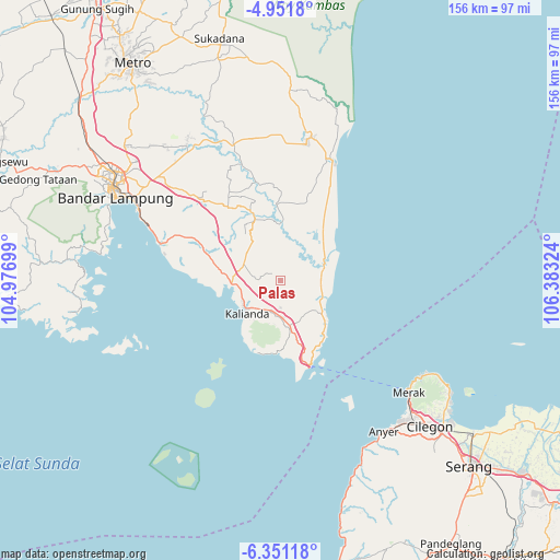
Palas GPS coordinates[2]
5° 39' 6.876" South, 105° 40' 48.396" East
| Map corner | latitude | longitude |
|---|---|---|
| Upper-left | -4.9518°, | 104.97699° |
| Center: | -5.65191°, | 105.68011° |
| Lower-right: | -6.35118°, | 106.38324° |
| Map W x H: | 155.6×155.6 km | = 96.7×96.7mi |
| max Lat: | 5.88969° ⇑11.8% North |
| Palas: | -5.65191° |
| min Lat: | ⇓88.2% South -10.934° |
| min Long | Palas | max Long |
| 95.1345° | 105.68011° | 140.9419° |
| W 5.9%⇐ | ⇒94.1% E |
Elevation
Elevation of Palas is 23 m = 75 ft, and this is 206.7 m = 678 ft below average elevation for this country.
| Max E: |
3185 m = 10449 ft | 76.2% |
| Avg. | 229.7 m = 754 ft | |
| Palas | 23 m = 75 ft | |
Min E: |
-1 m = -3 ft | 23.8% |
See also: Indonesia elevation on elevation.city.
Geographical zone
Palas is located in South Torrid zone (between Equator and Tropic of Capricorn). Distance of Equator is 628.4 km =390.5 mi to North.| Distance of | km | miles | from Palas |
|---|---|---|---|
| Equator | 628.4 | 390.5 | to North |
| Tropic Capricorn | 1977.5 | 1228.8 | to South |
| Antarctic Circle | 6772.7 | 4208.4 | to South |
| South Pole | 9378.6 | 5827.6 | to South |


Nearby cities:
15 places around Palas: (largest is in red/bold)
• Bandar Lampung
52.6 km =32.7 mi,  298°
298°
• Bandaragung
40 km =24.9 mi,  1°
1°
• Curug
52.4 km =32.6 mi,  134°
134°
• Jabung
21 km =13 mi,  356°
356°
• Jepara
53.7 km =33.4 mi, 2°
• Kalianda
13.7 km =8.5 mi,  225°
225°
• Kedaton
55.3 km =34.4 mi, 302°
• Kubangkepuh
47.3 km =29.4 mi, 125°
• Labuhanmaringgai
36.4 km =22.6 mi,  23°
23°
• Pakuncen
54.8 km =34.1 mi, 127°
• Pangarengan
55.1 km =34.2 mi, 128°
• Panjang
44.4 km =27.6 mi, 296°
• Pasuruan
10.5 km =6.5 mi,  181°
181°
• Penengahan
13.3 km =8.3 mi,  171°
171°
• Sidorejo
18.9 km =11.7 mi,  293°
293°
Sources, notices
• [Note1] Compared only with cities in Indonesia existing in our database
• [Src1] Map data: © OpenStreetMap contributors (CC-BY-SA)
• [Src2] Other city data from geonames.org with taken over terms of usage.
• [Src3] Geographical zone / Annual Mean Temperature by Robert A. Rohde @ Wikipedia
