Kemantren Satu geodata
Kemantren Satu (Central Java) is a seat of a fourth-order administrative division; located in Indonesia in Asia/Jakarta (GMT+7) time zone. In our database, there are 407 cities with bigger population. Compared to other cities in Indonesia, 56.6% of cities are located further ↑North; 67.2% of cities are located further →East and 80.9% of cities have higher elevation than Kemantren Satu. Note1


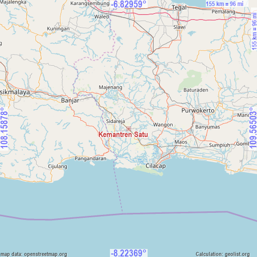
Kemantren Satu GPS coordinates[2]
7° 31' 37.92" South, 108° 51' 42.84" East
| Map corner | latitude | longitude |
|---|---|---|
| Upper-left | -6.82959°, | 108.15878° |
| Center: | -7.5272°, | 108.8619° |
| Lower-right: | -8.22369°, | 109.56503° |
| Map W x H: | 155×155 km | = 96.3×96.3mi |
| max Lat: | 5.88969° ⇑56.6% North |
| Kemantren Satu: | -7.5272° |
| min Lat: | ⇓43.4% South -10.934° |
| min Long | Kemantren Satu | max Long |
| 95.1345° | 108.8619° | 140.9419° |
| W 32.8%⇐ | ⇒67.2% E |
Elevation
Elevation of Kemantren Satu is 18 m = 59 ft, and this is 211.7 m = 695 ft below average elevation for this country.
| Max E: |
3185 m = 10449 ft | 80.9% |
| Avg. | 229.7 m = 754 ft | |
| Kemantren Satu | 18 m = 59 ft | |
Min E: |
-1 m = -3 ft | 19.1% |
See also: Indonesia elevation on elevation.city.
Geographical zone
Kemantren Satu is located in South Torrid zone (between Equator and Tropic of Capricorn). Distance of Equator is 836.9 km =520 mi to North.| Distance of | km | miles | from Kemantren Satu |
|---|---|---|---|
| Equator | 836.9 | 520 | to North |
| Tropic Capricorn | 1769 | 1099.2 | to South |
| Antarctic Circle | 6564.2 | 4078.8 | to South |
| South Pole | 9170.1 | 5698 | to South |


Nearby cities:
15 places around Kemantren Satu: (largest is in red/bold)
• Alurbulu
2.9 km =1.8 mi,  305°
305°
• Cawilayan
2.2 km =1.4 mi,  198°
198°
• Ciklapa
6.3 km =3.9 mi,  287°
287°
• Ciloning
6 km =3.7 mi,  349°
349°
• Cipari
6.8 km =4.2 mi,  260°
260°
• Dukuhtengah
6.8 km =4.2 mi,  279°
279°
• Gandrungmangu
1.2 km =0.7 mi, 309°
• Gandrungmanis Lor
0.6 km =0.4 mi,  253°
253°
• Gendiwu
6.9 km =4.3 mi, 306°
• Muktisari
1.6 km =1 mi,  338°
338°
• Sidakaya
5.4 km =3.4 mi,  177°
177°
• Sidamulya
7.6 km =4.7 mi,  304°
304°
• Sidaurip
3.6 km =2.2 mi,  227°
227°
• Tambangan
6.4 km =4 mi,  315°
315°
• Wanadadi
4.5 km =2.8 mi, 261°
Sources, notices
• [Note1] Compared only with cities in Indonesia existing in our database
• [Src1] Map data: © OpenStreetMap contributors (CC-BY-SA)
• [Src2] Other city data from geonames.org with taken over terms of usage.
• [Src3] Geographical zone / Annual Mean Temperature by Robert A. Rohde @ Wikipedia
