Gendiwu geodata
Gendiwu (Central Java) is a seat of a fourth-order administrative division; located in Indonesia in Asia/Jakarta (GMT+7) time zone. In our database, there are 407 cities with bigger population. Compared to other cities in Indonesia, 55.7% of cities are located further ↑North; 67.6% of cities are located further →East and 93.7% of cities have higher elevation than Gendiwu. Note1


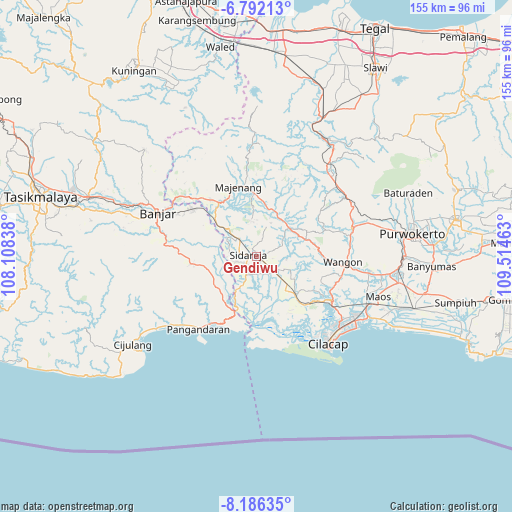
Gendiwu GPS coordinates[2]
7° 29' 23.28" South, 108° 48' 41.4" East
| Map corner | latitude | longitude |
|---|---|---|
| Upper-left | -6.79213°, | 108.10838° |
| Center: | -7.4898°, | 108.8115° |
| Lower-right: | -8.18635°, | 109.51463° |
| Map W x H: | 155×155 km | = 96.3×96.3mi |
| max Lat: | 5.88969° ⇑55.7% North |
| Gendiwu: | -7.4898° |
| min Lat: | ⇓44.3% South -10.934° |
| min Long | Gendiwu | max Long |
| 95.1345° | 108.8115° | 140.9419° |
| W 32.4%⇐ | ⇒67.6% E |
Elevation
Elevation of Gendiwu is 8 m = 26 ft, and this is 221.7 m = 727 ft below average elevation for this country.
| Max E: |
3185 m = 10449 ft | 93.7% |
| Avg. | 229.7 m = 754 ft | |
| Gendiwu | 8 m = 26 ft | |
Min E: |
-1 m = -3 ft | 6.3% |
See also: Indonesia elevation on elevation.city.
Geographical zone
Gendiwu is located in South Torrid zone (between Equator and Tropic of Capricorn). Distance of Equator is 832.8 km =517.5 mi to North.| Distance of | km | miles | from Gendiwu |
|---|---|---|---|
| Equator | 832.8 | 517.5 | to North |
| Tropic Capricorn | 1773.1 | 1101.8 | to South |
| Antarctic Circle | 6568.4 | 4081.4 | to South |
| South Pole | 9174.3 | 5700.6 | to South |


Nearby cities:
15 places around Gendiwu: (largest is in red/bold)
• Alurbulu
4 km =2.5 mi,  127°
127°
• Cikalong
2.4 km =1.5 mi,  294°
294°
• Ciklapa
2.3 km =1.4 mi,  191°
191°
• Cikondang
1.8 km =1.1 mi,  350°
350°
• Ciloning
4.7 km =2.9 mi,  69°
69°
• Citengah
3.9 km =2.4 mi,  278°
278°
• Dukuhtengah
3.3 km =2.1 mi,  200°
200°
• Kauman
3 km =1.9 mi, 291°
• Kedungbakung
4.5 km =2.8 mi,  247°
247°
• Kedungreja
3.9 km =2.4 mi,  244°
244°
• Mulyosari
3.4 km =2.1 mi, 235°
• Sidamulya
0.8 km =0.5 mi, 281°
• Sidareja
2.2 km =1.4 mi, 285°
• Tambangan
1.2 km =0.7 mi, 69°
• Wonodadi
4.3 km =2.7 mi,  33°
33°
Sources, notices
• [Note1] Compared only with cities in Indonesia existing in our database
• [Src1] Map data: © OpenStreetMap contributors (CC-BY-SA)
• [Src2] Other city data from geonames.org with taken over terms of usage.
• [Src3] Geographical zone / Annual Mean Temperature by Robert A. Rohde @ Wikipedia
