Cimrutu geodata
Cimrutu (Central Java) is a seat of a fourth-order administrative division; located in Indonesia in Asia/Jakarta (GMT+7) time zone. In our database, there are 407 cities with bigger population. Compared to other cities in Indonesia, 58.3% of cities are located further ↑North; 67.8% of cities are located further →East and 97.2% of cities have higher elevation than Cimrutu. Note1


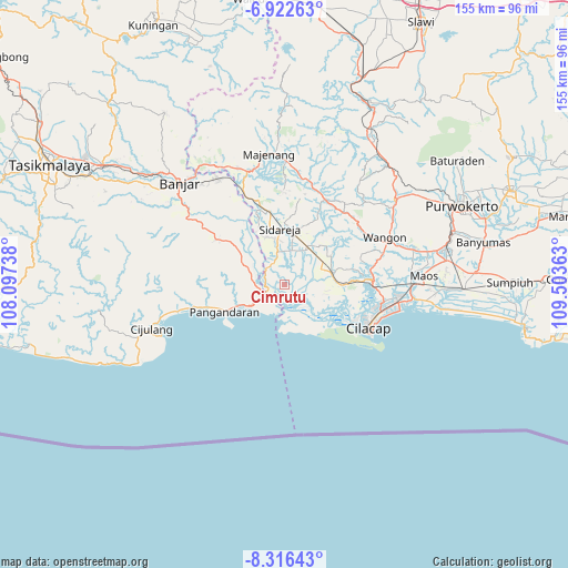
Cimrutu GPS coordinates[2]
7° 37' 12.36" South, 108° 48' 1.8" East
| Map corner | latitude | longitude |
|---|---|---|
| Upper-left | -6.92263°, | 108.09738° |
| Center: | -7.6201°, | 108.8005° |
| Lower-right: | -8.31643°, | 109.50363° |
| Map W x H: | 155×155 km | = 96.3×96.3mi |
| max Lat: | 5.88969° ⇑58.3% North |
| Cimrutu: | -7.6201° |
| min Lat: | ⇓41.7% South -10.934° |
| min Long | Cimrutu | max Long |
| 95.1345° | 108.8005° | 140.9419° |
| W 32.2%⇐ | ⇒67.8% E |
Elevation
Elevation of Cimrutu is 6 m = 20 ft, and this is 223.7 m = 734 ft below average elevation for this country.
| Max E: |
3185 m = 10449 ft | 97.2% |
| Avg. | 229.7 m = 754 ft | |
| Cimrutu | 6 m = 20 ft | |
Min E: |
-1 m = -3 ft | 2.8% |
See also: Indonesia elevation on elevation.city.
Geographical zone
Cimrutu is located in South Torrid zone (between Equator and Tropic of Capricorn). Distance of Equator is 847.3 km =526.5 mi to North.| Distance of | km | miles | from Cimrutu |
|---|---|---|---|
| Equator | 847.3 | 526.5 | to North |
| Tropic Capricorn | 1758.6 | 1092.7 | to South |
| Antarctic Circle | 6553.9 | 4072.4 | to South |
| South Pole | 9159.8 | 5691.6 | to South |


Nearby cities:
15 places around Cimrutu: (largest is in red/bold)
• Cibuluh Satu
6.9 km =4.3 mi,  251°
251°
• Cintamaju
8.4 km =5.2 mi,  275°
275°
• Cinyawang
6.4 km =4 mi,  323°
323°
• Kalenaren
4.8 km =3 mi,  339°
339°
• Kalenpring
5.8 km =3.6 mi,  311°
311°
• Kalipucang
5.9 km =3.7 mi,  243°
243°
• Karanganyar
5.5 km =3.4 mi,  156°
156°
• Kedungsalam
5.1 km =3.2 mi, 283°
• Mekarsari
8 km =5 mi,  210°
210°
• Pamotan
5.5 km =3.4 mi,  222°
222°
• Patimuan
5.6 km =3.5 mi,  295°
295°
• Pondokwungu
7.2 km =4.5 mi,  356°
356°
• Purwodadi
4.8 km =3 mi,  294°
294°
• Rawaapu
5.2 km =3.2 mi, 246°
• Sidakaya
8.6 km =5.3 mi,  54°
54°
Sources, notices
• [Note1] Compared only with cities in Indonesia existing in our database
• [Src1] Map data: © OpenStreetMap contributors (CC-BY-SA)
• [Src2] Other city data from geonames.org with taken over terms of usage.
• [Src3] Geographical zone / Annual Mean Temperature by Robert A. Rohde @ Wikipedia
