Nyungcung geodata
Nyungcung (Banten) is a seat of a fourth-order administrative division; located in Indonesia in Asia/Jakarta (GMT+7) time zone. In our database, there are 407 cities with bigger population. Compared to other cities in Indonesia, 79.8% of cities are located further ↓South; 89.1% of cities are located further →East and 76.4% of cities have lower elevation than Nyungcung. Note1


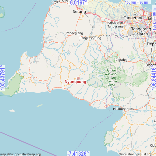
Nyungcung GPS coordinates[2]
6° 42' 55.728" South, 106° 8' 27.708" East
| Map corner | latitude | longitude |
|---|---|---|
| Upper-left | -6.0167°, | 105.43791° |
| Center: | -6.71548°, | 106.14103° |
| Lower-right: | -7.41326°, | 106.84416° |
| Map W x H: | 155.3×155.3 km | = 96.5×96.5mi |
| max Lat: | 5.88969° ⇑20.2% North |
| Nyungcung: | -6.71548° |
| min Lat: | ⇓79.8% South -10.934° |
| min Long | Nyungcung | max Long |
| 95.1345° | 106.14103° | 140.9419° |
| W 10.9%⇐ | ⇒89.1% E |
Elevation
Elevation of Nyungcung is 378 m = 1240 ft, and this is 148.3 m = 487 ft above average elevation for this country.
| Max E: |
3185 m = 10449 ft | 23.6% |
| Nyungcung | 378 m 1240 ft | |
| Avg. | 229.7 m = 754 ft | |
Min E: |
-1 m = -3 ft | 76.4% |
See also: Indonesia elevation on elevation.city.
Geographical zone
Nyungcung is located in South Torrid zone (between Equator and Tropic of Capricorn). Distance of Equator is 746.7 km =464 mi to North.| Distance of | km | miles | from Nyungcung |
|---|---|---|---|
| Equator | 746.7 | 464 | to North |
| Tropic Capricorn | 1859.2 | 1155.3 | to South |
| Antarctic Circle | 6654.5 | 4134.9 | to South |
| South Pole | 9260.4 | 5754.1 | to South |


Nearby cities:
15 places around Nyungcung: (largest is in red/bold)
• Ciapus
6.9 km =4.3 mi,  240°
240°
• Cigaber
10 km =6.2 mi,  200°
200°
• Cigemlong
2 km =1.2 mi,  113°
113°
• Cikadu
9.5 km =5.9 mi,  212°
212°
• Cikaras
7.6 km =4.7 mi,  174°
174°
• Cikate
8.4 km =5.2 mi,  100°
100°
• Cikawung
5.2 km =3.2 mi,  143°
143°
• Cipeundeuy
3.5 km =2.2 mi,  298°
298°
• Cipicung Timur
5.8 km =3.6 mi,  38°
38°
• Cirinten
9.4 km =5.8 mi,  10°
10°
• Datarcae
7.6 km =4.7 mi,  18°
18°
• Manglid
6.2 km =3.9 mi, 211°
• Parigi
9.2 km =5.7 mi, 41°
• Peucangpari
3.3 km =2.1 mi,  277°
277°
• Sukamaju
7.9 km =4.9 mi, 278°
Sources, notices
• [Note1] Compared only with cities in Indonesia existing in our database
• [Src1] Map data: © OpenStreetMap contributors (CC-BY-SA)
• [Src2] Other city data from geonames.org with taken over terms of usage.
• [Src3] Geographical zone / Annual Mean Temperature by Robert A. Rohde @ Wikipedia
