Cigaber geodata
Cigaber (Banten) is a seat of a fourth-order administrative division; located in Indonesia in Asia/Jakarta (GMT+7) time zone. In our database, there are 407 cities with bigger population. Compared to other cities in Indonesia, 76.4% of cities are located further ↓South; 89.4% of cities are located further →East and 63% of cities have lower elevation than Cigaber. Note1


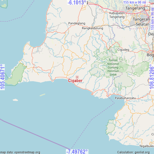
Cigaber GPS coordinates[2]
6° 47' 59.892" South, 106° 6' 35.388" East
| Map corner | latitude | longitude |
|---|---|---|
| Upper-left | -6.1013°, | 105.40671° |
| Center: | -6.79997°, | 106.10983° |
| Lower-right: | -7.49762°, | 106.81296° |
| Map W x H: | 155.3×155.3 km | = 96.5×96.5mi |
| max Lat: | 5.88969° ⇑23.6% North |
| Cigaber: | -6.79997° |
| min Lat: | ⇓76.4% South -10.934° |
| min Long | Cigaber | max Long |
| 95.1345° | 106.10983° | 140.9419° |
| W 10.6%⇐ | ⇒89.4% E |
Elevation
Elevation of Cigaber is 197 m = 646 ft, and this is 32.7 m = 107 ft below average elevation for this country.
| Max E: |
3185 m = 10449 ft | 37% |
| Avg. | 229.7 m = 754 ft | |
| Cigaber | 197 m = 646 ft | |
Min E: |
-1 m = -3 ft | 63% |
See also: Indonesia elevation on elevation.city.
Geographical zone
Cigaber is located in South Torrid zone (between Equator and Tropic of Capricorn). Distance of Equator is 756.1 km =469.8 mi to North.| Distance of | km | miles | from Cigaber |
|---|---|---|---|
| Equator | 756.1 | 469.8 | to North |
| Tropic Capricorn | 1849.8 | 1149.4 | to South |
| Antarctic Circle | 6645.1 | 4129.1 | to South |
| South Pole | 9251 | 5748.3 | to South |


Nearby cities:
15 places around Cigaber: (largest is in red/bold)
• Bangbayang
9.7 km =6 mi,  131°
131°
• Ciapus
6.5 km =4 mi,  337°
337°
• Cicatang Satu
7.2 km =4.5 mi,  182°
182°
• Cikadu
2.1 km =1.3 mi,  309°
309°
• Cikaras
4.6 km =2.9 mi,  66°
66°
• Cikawung
8.3 km =5.2 mi,  51°
51°
• Cimandiri
9.3 km =5.8 mi, 132°
• Citaritih
6.8 km =4.2 mi,  247°
247°
• Manglid
4.2 km =2.6 mi,  2°
2°
• Nyungcung
10 km =6.2 mi,  20°
20°
• Pagelaran
7.9 km =4.9 mi,  257°
257°
• Pasirnangka
3.7 km =2.3 mi,  206°
206°
• Peucangpari
9.8 km =6.1 mi, 0°
• Sukamaju
7.3 km =4.5 mi,  295°
295°
• Sukaraja
9.5 km =5.9 mi,  278°
278°
Sources, notices
• [Note1] Compared only with cities in Indonesia existing in our database
• [Src1] Map data: © OpenStreetMap contributors (CC-BY-SA)
• [Src2] Other city data from geonames.org with taken over terms of usage.
• [Src3] Geographical zone / Annual Mean Temperature by Robert A. Rohde @ Wikipedia
