Kukuluk geodata
Kukuluk (Banten) is a seat of a fourth-order administrative division; located in Indonesia in Asia/Jakarta (GMT+7) time zone. In our database, there are 407 cities with bigger population. Compared to other cities in Indonesia, 83.3% of cities are located further ↓South; 91.2% of cities are located further →East and 62.8% of cities have higher elevation than Kukuluk. Note1


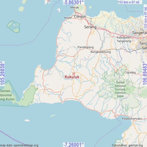
Kukuluk GPS coordinates[2]
6° 33' 43.2" South, 105° 59' 30.12" East
| Map corner | latitude | longitude |
|---|---|---|
| Upper-left | -5.86301°, | 105.28858° |
| Center: | -6.562°, | 105.9917° |
| Lower-right: | -7.26001°, | 106.69483° |
| Map W x H: | 155.3×155.3 km | = 96.5×96.5mi |
| max Lat: | 5.88969° ⇑16.7% North |
| Kukuluk: | -6.562° |
| min Lat: | ⇓83.3% South -10.934° |
| min Long | Kukuluk | max Long |
| 95.1345° | 105.9917° | 140.9419° |
| W 8.8%⇐ | ⇒91.2% E |
Elevation
Elevation of Kukuluk is 49 m = 161 ft, and this is 180.7 m = 593 ft below average elevation for this country.
| Max E: |
3185 m = 10449 ft | 62.8% |
| Avg. | 229.7 m = 754 ft | |
| Kukuluk | 49 m = 161 ft | |
Min E: |
-1 m = -3 ft | 37.2% |
See also: Indonesia elevation on elevation.city.
Geographical zone
Kukuluk is located in South Torrid zone (between Equator and Tropic of Capricorn). Distance of Equator is 729.6 km =453.4 mi to North.| Distance of | km | miles | from Kukuluk |
|---|---|---|---|
| Equator | 729.6 | 453.4 | to North |
| Tropic Capricorn | 1876.3 | 1165.9 | to South |
| Antarctic Circle | 6671.5 | 4145.5 | to South |
| South Pole | 9277.4 | 5764.7 | to South |


Nearby cities:
15 places around Kukuluk: (largest is in red/bold)
• Cibeusi
4.9 km =3 mi,  78°
78°
• Cilegong
1.7 km =1.1 mi,  27°
27°
• Cimoyan
4.3 km =2.7 mi,  317°
317°
• Ciodeng
5.1 km =3.2 mi,  248°
248°
• Ciruji Dua
3.6 km =2.2 mi,  352°
352°
• Jalupang Dua
2.3 km =1.4 mi,  12°
12°
• Kadumula
5.8 km =3.6 mi,  330°
330°
• Kampungruweh
2.5 km =1.6 mi,  200°
200°
• Kebonkalapa
5 km =3.1 mi,  128°
128°
• Lebakkeusik
6.2 km =3.9 mi,  225°
225°
• Manggu
5.3 km =3.3 mi, 195°
• Mangpeng
3.1 km =1.9 mi,  101°
101°
• Pakis
3.4 km =2.1 mi,  273°
273°
• Tunasbaru
6 km =3.7 mi, 8°
• Warungsugan
3.8 km =2.4 mi, 203°
Sources, notices
• [Note1] Compared only with cities in Indonesia existing in our database
• [Src1] Map data: © OpenStreetMap contributors (CC-BY-SA)
• [Src2] Other city data from geonames.org with taken over terms of usage.
• [Src3] Geographical zone / Annual Mean Temperature by Robert A. Rohde @ Wikipedia
