Kadumula geodata
Kadumula (Banten) is a seat of a fourth-order administrative division; located in Indonesia in Asia/Jakarta (GMT+7) time zone. In our database, there are 407 cities with bigger population. Compared to other cities in Indonesia, 84.1% of cities are located further ↓South; 91.5% of cities are located further →East and 57.7% of cities have higher elevation than Kadumula. Note1


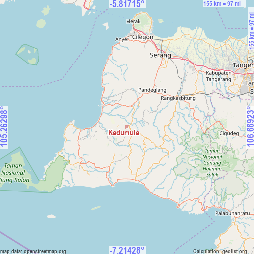
Kadumula GPS coordinates[2]
6° 30' 58.32" South, 105° 57' 57.96" East
| Map corner | latitude | longitude |
|---|---|---|
| Upper-left | -5.81715°, | 105.26298° |
| Center: | -6.5162°, | 105.9661° |
| Lower-right: | -7.21428°, | 106.66923° |
| Map W x H: | 155.3×155.4 km | = 96.5×96.6mi |
| max Lat: | 5.88969° ⇑15.9% North |
| Kadumula: | -6.5162° |
| min Lat: | ⇓84.1% South -10.934° |
| min Long | Kadumula | max Long |
| 95.1345° | 105.9661° | 140.9419° |
| W 8.5%⇐ | ⇒91.5% E |
Elevation
Elevation of Kadumula is 69 m = 226 ft, and this is 160.7 m = 527 ft below average elevation for this country.
| Max E: |
3185 m = 10449 ft | 57.7% |
| Avg. | 229.7 m = 754 ft | |
| Kadumula | 69 m = 226 ft | |
Min E: |
-1 m = -3 ft | 42.3% |
See also: Indonesia elevation on elevation.city.
Geographical zone
Kadumula is located in South Torrid zone (between Equator and Tropic of Capricorn). Distance of Equator is 724.5 km =450.2 mi to North.| Distance of | km | miles | from Kadumula |
|---|---|---|---|
| Equator | 724.5 | 450.2 | to North |
| Tropic Capricorn | 1881.4 | 1169 | to South |
| Antarctic Circle | 6676.6 | 4148.6 | to South |
| South Pole | 9282.5 | 5767.9 | to South |


Nearby cities:
15 places around Kadumula: (largest is in red/bold)
• Cilegong
5.1 km =3.2 mi,  134°
134°
• Cililitan
1.7 km =1.1 mi,  50°
50°
• Cimadang
6 km =3.7 mi,  38°
38°
• Cimoyan
1.9 km =1.2 mi,  182°
182°
• Ciruji Dua
2.8 km =1.7 mi,  123°
123°
• Jalupang Dua
4.4 km =2.7 mi, 130°
• Kadumelati
5.1 km =3.2 mi,  283°
283°
• Kadupandak
1.2 km =0.7 mi,  15°
15°
• Kukuluk
5.8 km =3.6 mi,  150°
150°
• Langkapcaang Hilir
5.9 km =3.7 mi,  232°
232°
• Nambo
3.2 km =2 mi,  327°
327°
• Pakis
4.9 km =3 mi,  186°
186°
• Pasarbaru
3.3 km =2.1 mi,  260°
260°
• Pematang
3.3 km =2.1 mi,  285°
285°
• Tunasbaru
3.8 km =2.4 mi,  77°
77°
Sources, notices
• [Note1] Compared only with cities in Indonesia existing in our database
• [Src1] Map data: © OpenStreetMap contributors (CC-BY-SA)
• [Src2] Other city data from geonames.org with taken over terms of usage.
• [Src3] Geographical zone / Annual Mean Temperature by Robert A. Rohde @ Wikipedia
