Pasarbaru geodata
Pasarbaru (Banten) is a seat of a fourth-order administrative division; located in Indonesia in Asia/Jakarta (GMT+7) time zone. In our database, there are 407 cities with bigger population. Compared to other cities in Indonesia, 84.1% of cities are located further ↓South; 91.9% of cities are located further →East and 70.7% of cities have higher elevation than Pasarbaru. Note1


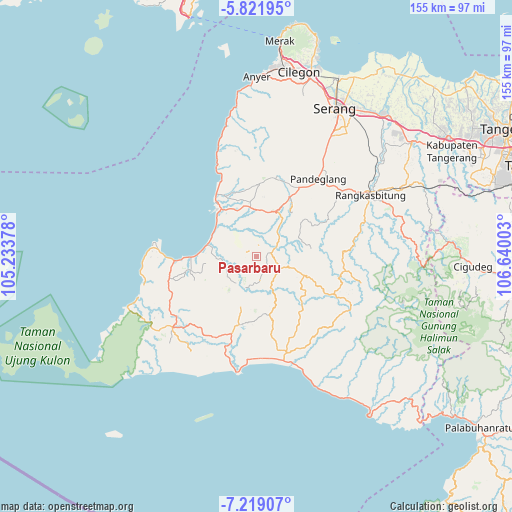
Pasarbaru GPS coordinates[2]
6° 31' 15.6" South, 105° 56' 12.84" East
| Map corner | latitude | longitude |
|---|---|---|
| Upper-left | -5.82195°, | 105.23378° |
| Center: | -6.521°, | 105.9369° |
| Lower-right: | -7.21907°, | 106.64003° |
| Map W x H: | 155.3×155.3 km | = 96.5×96.5mi |
| max Lat: | 5.88969° ⇑15.9% North |
| Pasarbaru: | -6.521° |
| min Lat: | ⇓84.1% South -10.934° |
| min Long | Pasarbaru | max Long |
| 95.1345° | 105.9369° | 140.9419° |
| W 8.1%⇐ | ⇒91.9% E |
Elevation
Elevation of Pasarbaru is 31 m = 102 ft, and this is 198.7 m = 652 ft below average elevation for this country.
| Max E: |
3185 m = 10449 ft | 70.7% |
| Avg. | 229.7 m = 754 ft | |
| Pasarbaru | 31 m = 102 ft | |
Min E: |
-1 m = -3 ft | 29.3% |
See also: Indonesia elevation on elevation.city.
Geographical zone
Pasarbaru is located in South Torrid zone (between Equator and Tropic of Capricorn). Distance of Equator is 725.1 km =450.6 mi to North.| Distance of | km | miles | from Pasarbaru |
|---|---|---|---|
| Equator | 725.1 | 450.6 | to North |
| Tropic Capricorn | 1880.9 | 1168.7 | to South |
| Antarctic Circle | 6676.1 | 4148.3 | to South |
| South Pole | 9282 | 5767.6 | to South |


Nearby cities:
15 places around Pasarbaru: (largest is in red/bold)
• Campaka
3.2 km =2 mi,  215°
215°
• Cililitan
4.8 km =3 mi,  70°
70°
• Cimoyan
3.4 km =2.1 mi,  113°
113°
• Ciruji Dua
5.7 km =3.5 mi,  100°
100°
• Kadumelati
2.4 km =1.5 mi,  314°
314°
• Kadumula
3.3 km =2.1 mi,  80°
80°
• Kadupandak
3.9 km =2.4 mi,  64°
64°
• Kampungbaru
4.3 km =2.7 mi,  251°
251°
• Langkapcaang Hilir
3.4 km =2.1 mi,  205°
205°
• Nambo
3.6 km =2.2 mi,  25°
25°
• Pakis
5.1 km =3.2 mi,  148°
148°
• Pasirgadung Satu
5.2 km =3.2 mi, 308°
• Pasirloa
5.9 km =3.7 mi, 247°
• Pasirpanjang
4.9 km =3 mi,  346°
346°
• Pematang
1.4 km =0.9 mi,  1°
1°
Sources, notices
• [Note1] Compared only with cities in Indonesia existing in our database
• [Src1] Map data: © OpenStreetMap contributors (CC-BY-SA)
• [Src2] Other city data from geonames.org with taken over terms of usage.
• [Src3] Geographical zone / Annual Mean Temperature by Robert A. Rohde @ Wikipedia
