Kandangsapi geodata
Kandangsapi (Banten) is a seat of a fourth-order administrative division; located in Indonesia in Asia/Jakarta (GMT+7) time zone. In our database, there are 407 cities with bigger population. Compared to other cities in Indonesia, 78.6% of cities are located further ↓South; 90.5% of cities are located further →East and 63.7% of cities have lower elevation than Kandangsapi. Note1


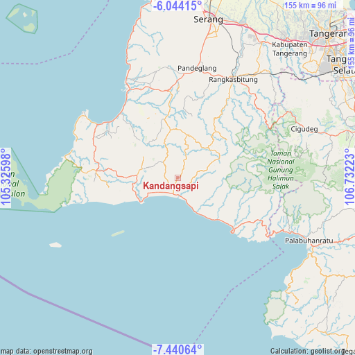
Kandangsapi GPS coordinates[2]
6° 44' 34.44" South, 106° 1' 44.76" East
| Map corner | latitude | longitude |
|---|---|---|
| Upper-left | -6.04415°, | 105.32598° |
| Center: | -6.7429°, | 106.0291° |
| Lower-right: | -7.44064°, | 106.73223° |
| Map W x H: | 155.3×155.3 km | = 96.5×96.5mi |
| max Lat: | 5.88969° ⇑21.4% North |
| Kandangsapi: | -6.7429° |
| min Lat: | ⇓78.6% South -10.934° |
| min Long | Kandangsapi | max Long |
| 95.1345° | 106.0291° | 140.9419° |
| W 9.5%⇐ | ⇒90.5% E |
Elevation
Elevation of Kandangsapi is 204 m = 669 ft, and this is 25.7 m = 84 ft below average elevation for this country.
| Max E: |
3185 m = 10449 ft | 36.3% |
| Avg. | 229.7 m = 754 ft | |
| Kandangsapi | 204 m = 669 ft | |
Min E: |
-1 m = -3 ft | 63.7% |
See also: Indonesia elevation on elevation.city.
Geographical zone
Kandangsapi is located in South Torrid zone (between Equator and Tropic of Capricorn). Distance of Equator is 749.7 km =465.8 mi to North.| Distance of | km | miles | from Kandangsapi |
|---|---|---|---|
| Equator | 749.7 | 465.8 | to North |
| Tropic Capricorn | 1856.2 | 1153.4 | to South |
| Antarctic Circle | 6651.4 | 4133 | to South |
| South Pole | 9257.3 | 5752.2 | to South |


Nearby cities:
15 places around Kandangsapi: (largest is in red/bold)
• Bolang
4.7 km =2.9 mi,  237°
237°
• Ciapus
6.4 km =4 mi,  93°
93°
• Citeureup
4.3 km =2.7 mi,  223°
223°
• Daleum
6.7 km =4.2 mi,  261°
261°
• Gintung Utara
5.8 km =3.6 mi,  284°
284°
• Kadujajar
0.7 km =0.4 mi,  208°
208°
• Malingping
4.1 km =2.5 mi,  197°
197°
• Pagenggang Selatan
4.7 km =2.9 mi, 262°
• Pamundayan Kaler
5.2 km =3.2 mi,  355°
355°
• Pasirhaur
4 km =2.5 mi, 199°
• Sanghiang
3.8 km =2.4 mi,  230°
230°
• Simpanggarung
4.3 km =2.7 mi,  31°
31°
• Sukamaju
4 km =2.5 mi,  143°
143°
• Sukamaju
6.2 km =3.9 mi,  47°
47°
• Sukaraja
4.9 km =3 mi,  185°
185°
Sources, notices
• [Note1] Compared only with cities in Indonesia existing in our database
• [Src1] Map data: © OpenStreetMap contributors (CC-BY-SA)
• [Src2] Other city data from geonames.org with taken over terms of usage.
• [Src3] Geographical zone / Annual Mean Temperature by Robert A. Rohde @ Wikipedia
