Sajir geodata
Sajir (Banten) is a seat of a third-order administrative division; located in Indonesia in Asia/Jakarta (GMT+7) time zone. In our database, there are 407 cities with bigger population. Compared to other cities in Indonesia, 84.3% of cities are located further ↓South; 89.8% of cities are located further →East and 54% of cities have lower elevation than Sajir. Note1


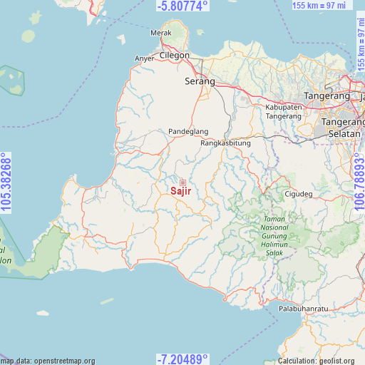
Sajir GPS coordinates[2]
6° 30' 24.48" South, 106° 5' 8.88" East
| Map corner | latitude | longitude |
|---|---|---|
| Upper-left | -5.80774°, | 105.38268° |
| Center: | -6.5068°, | 106.0858° |
| Lower-right: | -7.20489°, | 106.78893° |
| Map W x H: | 155.3×155.4 km | = 96.5×96.6mi |
| max Lat: | 5.88969° ⇑15.7% North |
| Sajir: | -6.5068° |
| min Lat: | ⇓84.3% South -10.934° |
| min Long | Sajir | max Long |
| 95.1345° | 106.0858° | 140.9419° |
| W 10.2%⇐ | ⇒89.8% E |
Elevation
Elevation of Sajir is 119 m = 390 ft, and this is 110.7 m = 363 ft below average elevation for this country.
| Max E: |
3185 m = 10449 ft | 46% |
| Avg. | 229.7 m = 754 ft | |
| Sajir | 119 m = 390 ft | |
Min E: |
-1 m = -3 ft | 54% |
See also: Indonesia elevation on elevation.city.
Geographical zone
Sajir is located in South Torrid zone (between Equator and Tropic of Capricorn). Distance of Equator is 723.5 km =449.6 mi to North.| Distance of | km | miles | from Sajir |
|---|---|---|---|
| Equator | 723.5 | 449.6 | to North |
| Tropic Capricorn | 1882.4 | 1169.7 | to South |
| Antarctic Circle | 6677.7 | 4149.3 | to South |
| South Pole | 9283.6 | 5768.6 | to South |


Nearby cities:
15 places around Sajir: (largest is in red/bold)
• Cahayamekar
5.3 km =3.3 mi,  261°
261°
• Cibeusi
7.6 km =4.7 mi,  227°
227°
• Cilutung
6.6 km =4.1 mi,  187°
187°
• Cipadung
8 km =5 mi,  283°
283°
• Gemuruh
7.5 km =4.7 mi,  2°
2°
• Gunungkencana
7.4 km =4.6 mi, 190°
• Kaum
4.6 km =2.9 mi,  46°
46°
• Keboncau
2.4 km =1.5 mi,  132°
132°
• Lebakgempol
4.4 km =2.7 mi,  7°
7°
• Munturkaju
6.8 km =4.2 mi,  266°
266°
• Parag
7.3 km =4.5 mi,  296°
296°
• Sarageni
6.1 km =3.8 mi,  41°
41°
• Sidamukti
6.9 km =4.3 mi,  331°
331°
• Tajur
2.7 km =1.7 mi,  199°
199°
• Umbul
6.9 km =4.3 mi, 6°
Sources, notices
• [Note1] Compared only with cities in Indonesia existing in our database
• [Src1] Map data: © OpenStreetMap contributors (CC-BY-SA)
• [Src2] Other city data from geonames.org with taken over terms of usage.
• [Src3] Geographical zone / Annual Mean Temperature by Robert A. Rohde @ Wikipedia
