Puputan geodata
Puputan (Banten) is a seat of a fourth-order administrative division; located in Indonesia in Asia/Jakarta (GMT+7) time zone. In our database, there are 407 cities with bigger population. Compared to other cities in Indonesia, 83.4% of cities are located further ↓South; 88.1% of cities are located further →East and 64.5% of cities have lower elevation than Puputan. Note1


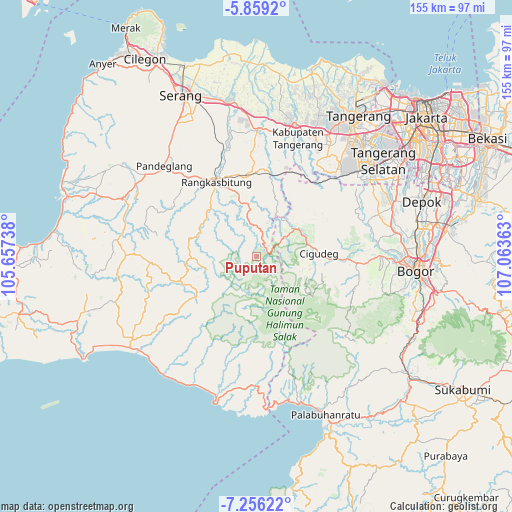
Puputan GPS coordinates[2]
6° 33' 29.52" South, 106° 21' 37.8" East
| Map corner | latitude | longitude |
|---|---|---|
| Upper-left | -5.8592°, | 105.65738° |
| Center: | -6.5582°, | 106.3605° |
| Lower-right: | -7.25622°, | 107.06363° |
| Map W x H: | 155.3×155.3 km | = 96.5×96.5mi |
| max Lat: | 5.88969° ⇑16.6% North |
| Puputan: | -6.5582° |
| min Lat: | ⇓83.4% South -10.934° |
| min Long | Puputan | max Long |
| 95.1345° | 106.3605° | 140.9419° |
| W 11.9%⇐ | ⇒88.1% E |
Elevation
Elevation of Puputan is 215 m = 705 ft, and this is 14.7 m = 48 ft below average elevation for this country.
| Max E: |
3185 m = 10449 ft | 35.5% |
| Avg. | 229.7 m = 754 ft | |
| Puputan | 215 m = 705 ft | |
Min E: |
-1 m = -3 ft | 64.5% |
See also: Indonesia elevation on elevation.city.
Geographical zone
Puputan is located in South Torrid zone (between Equator and Tropic of Capricorn). Distance of Equator is 729.2 km =453.1 mi to North.| Distance of | km | miles | from Puputan |
|---|---|---|---|
| Equator | 729.2 | 453.1 | to North |
| Tropic Capricorn | 1876.7 | 1166.1 | to South |
| Antarctic Circle | 6672 | 4145.8 | to South |
| South Pole | 9277.9 | 5765 | to South |


Nearby cities:
15 places around Puputan: (largest is in red/bold)
• Cibeurih
3.7 km =2.3 mi,  287°
287°
• Cigebrok
1.5 km =0.9 mi,  123°
123°
• Cikarae
2.3 km =1.4 mi,  89°
89°
• Cimarkum
1.5 km =0.9 mi,  247°
247°
• Cipanas
4.3 km =2.7 mi,  77°
77°
• Cipunglu
3.7 km =2.3 mi, 253°
• Gajrug
4.1 km =2.5 mi,  31°
31°
• Hamberang Sabrang
5.2 km =3.2 mi,  64°
64°
• Kadubitung
2.5 km =1.6 mi,  340°
340°
• Leuwisema
3.7 km =2.3 mi,  23°
23°
• Lurah
3.9 km =2.4 mi,  45°
45°
• Malangnengah
3.2 km =2 mi,  358°
358°
• Padurung
4.6 km =2.9 mi,  134°
134°
• Siangin
2.5 km =1.6 mi,  242°
242°
• Sukamaju
4.5 km =2.8 mi, 46°
Sources, notices
• [Note1] Compared only with cities in Indonesia existing in our database
• [Src1] Map data: © OpenStreetMap contributors (CC-BY-SA)
• [Src2] Other city data from geonames.org with taken over terms of usage.
• [Src3] Geographical zone / Annual Mean Temperature by Robert A. Rohde @ Wikipedia
