Pamungguan geodata
Pamungguan (West Java) is a seat of a fourth-order administrative division; located in Indonesia in Asia/Jakarta (GMT+7) time zone. In our database, there are 407 cities with bigger population. Compared to other cities in Indonesia, 55.3% of cities are located further ↑North; 83.7% of cities are located further →East and 72.5% of cities have lower elevation than Pamungguan. Note1


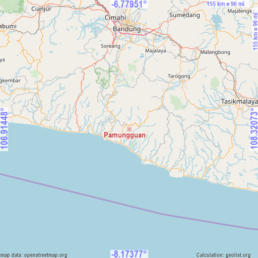
Pamungguan GPS coordinates[2]
7° 28' 37.92" South, 107° 37' 3.36" East
| Map corner | latitude | longitude |
|---|---|---|
| Upper-left | -6.77951°, | 106.91448° |
| Center: | -7.4772°, | 107.6176° |
| Lower-right: | -8.17377°, | 108.32073° |
| Map W x H: | 155×155 km | = 96.3×96.3mi |
| max Lat: | 5.88969° ⇑55.3% North |
| Pamungguan: | -7.4772° |
| min Lat: | ⇓44.7% South -10.934° |
| min Long | Pamungguan | max Long |
| 95.1345° | 107.6176° | 140.9419° |
| W 16.3%⇐ | ⇒83.7% E |
Elevation
Elevation of Pamungguan is 328 m = 1076 ft, and this is 98.3 m = 323 ft above average elevation for this country.
| Max E: |
3185 m = 10449 ft | 27.5% |
| Pamungguan | 328 m 1076 ft | |
| Avg. | 229.7 m = 754 ft | |
Min E: |
-1 m = -3 ft | 72.5% |
See also: Indonesia elevation on elevation.city.
Geographical zone
Pamungguan is located in South Torrid zone (between Equator and Tropic of Capricorn). Distance of Equator is 831.4 km =516.6 mi to North.| Distance of | km | miles | from Pamungguan |
|---|---|---|---|
| Equator | 831.4 | 516.6 | to North |
| Tropic Capricorn | 1774.5 | 1102.6 | to South |
| Antarctic Circle | 6569.8 | 4082.3 | to South |
| South Pole | 9175.7 | 5701.5 | to South |


Nearby cities:
15 places around Pamungguan: (largest is in red/bold)
• Babakansalam
2.9 km =1.8 mi,  162°
162°
• Batutumpang
4.5 km =2.8 mi,  8°
8°
• Bokor
5.3 km =3.3 mi,  185°
185°
• Bungbulang
3.1 km =1.9 mi,  318°
318°
• Cibolang
4.7 km =2.9 mi,  337°
337°
• Cikuya
4.9 km =3 mi,  292°
292°
• Hanjuang
2.8 km =1.7 mi,  299°
299°
• Nagrak
4.2 km =2.6 mi,  325°
325°
• Nangkaruka
5.8 km =3.6 mi,  32°
32°
• Pasireunteung
5.1 km =3.2 mi,  236°
236°
• Pasirwangi
5.5 km =3.4 mi,  70°
70°
• Rahayu
3.5 km =2.2 mi,  55°
55°
• Simpang
5.7 km =3.5 mi,  86°
86°
• Tegalastana
2.4 km =1.5 mi, 243°
• Tegalgede
4.3 km =2.7 mi,  112°
112°
Sources, notices
• [Note1] Compared only with cities in Indonesia existing in our database
• [Src1] Map data: © OpenStreetMap contributors (CC-BY-SA)
• [Src2] Other city data from geonames.org with taken over terms of usage.
• [Src3] Geographical zone / Annual Mean Temperature by Robert A. Rohde @ Wikipedia
