Gugunungan geodata
Gugunungan (West Java) is a seat of a fourth-order administrative division; located in Indonesia in Asia/Jakarta (GMT+7) time zone. In our database, there are 407 cities with bigger population. Compared to other cities in Indonesia, 53.6% of cities are located further ↓South; 81.7% of cities are located further →East and 94.1% of cities have lower elevation than Gugunungan. Note1


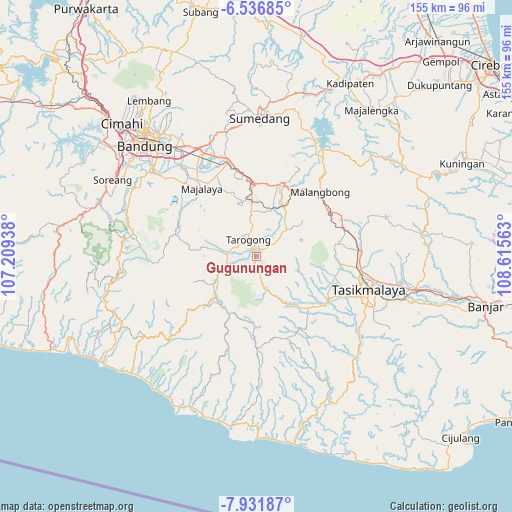
Gugunungan GPS coordinates[2]
7° 14' 5.64" South, 107° 54' 45" East
| Map corner | latitude | longitude |
|---|---|---|
| Upper-left | -6.53685°, | 107.20938° |
| Center: | -7.2349°, | 107.9125° |
| Lower-right: | -7.93187°, | 108.61563° |
| Map W x H: | 155.1×155.1 km | = 96.4×96.4mi |
| max Lat: | 5.88969° ⇑46.4% North |
| Gugunungan: | -7.2349° |
| min Lat: | ⇓53.6% South -10.934° |
| min Long | Gugunungan | max Long |
| 95.1345° | 107.9125° | 140.9419° |
| W 18.3%⇐ | ⇒81.7% E |
Elevation
Elevation of Gugunungan is 772 m = 2533 ft, and this is 542.3 m = 1779 ft above average elevation for this country.
| Max E: |
3185 m = 10449 ft | 5.9% |
| Gugunungan | 772 m 2533 ft | |
| Avg. | 229.7 m = 754 ft | |
Min E: |
-1 m = -3 ft | 94.1% |
See also: Indonesia elevation on elevation.city.
Geographical zone
Gugunungan is located in South Torrid zone (between Equator and Tropic of Capricorn). Distance of Equator is 804.4 km =499.8 mi to North.| Distance of | km | miles | from Gugunungan |
|---|---|---|---|
| Equator | 804.4 | 499.8 | to North |
| Tropic Capricorn | 1801.5 | 1119.4 | to South |
| Antarctic Circle | 6596.7 | 4099 | to South |
| South Pole | 9202.6 | 5718.2 | to South |


Nearby cities:
15 places around Gugunungan: (largest is in red/bold)
• Babakan Baru
2.4 km =1.5 mi,  138°
138°
• Bentar Girang
2.6 km =1.6 mi,  357°
357°
• Besarmanah
2.5 km =1.6 mi,  295°
295°
• Cangkuang
1.5 km =0.9 mi, 301°
• Cimaragas
1.2 km =0.7 mi,  202°
202°
• Ciwalen
2.2 km =1.4 mi,  351°
351°
• Gunungsatria
1.2 km =0.7 mi,  326°
326°
• Kudang
2.6 km =1.6 mi,  41°
41°
• Mawar
2.6 km =1.6 mi,  341°
341°
• Nangerang
0.9 km =0.6 mi,  95°
95°
• Ngamplang
2.6 km =1.6 mi,  212°
212°
• Pakuwon
2.4 km =1.5 mi, 335°
• Suci Kaler
2.4 km =1.5 mi,  27°
27°
• Suci Kidul
2.2 km =1.4 mi, 29°
• Taluncemara
1.8 km =1.1 mi, 343°
Sources, notices
• [Note1] Compared only with cities in Indonesia existing in our database
• [Src1] Map data: © OpenStreetMap contributors (CC-BY-SA)
• [Src2] Other city data from geonames.org with taken over terms of usage.
• [Src3] Geographical zone / Annual Mean Temperature by Robert A. Rohde @ Wikipedia
