Ngamplang geodata
Ngamplang (West Java) is a seat of a fourth-order administrative division; located in Indonesia in Asia/Jakarta (GMT+7) time zone. In our database, there are 407 cities with bigger population. Compared to other cities in Indonesia, 53% of cities are located further ↓South; 82% of cities are located further →East and 96.3% of cities have lower elevation than Ngamplang. Note1


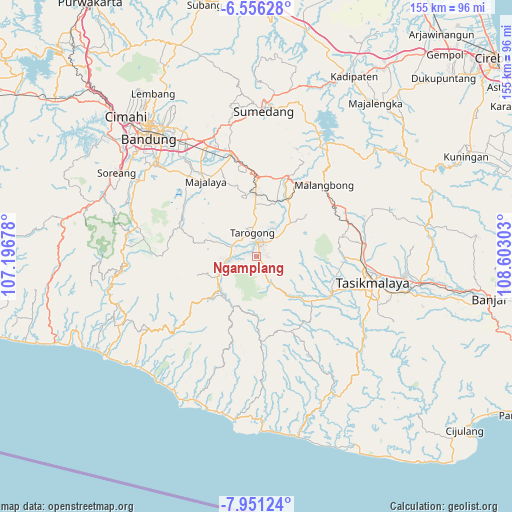
Ngamplang GPS coordinates[2]
7° 15' 15.48" South, 107° 53' 59.64" East
| Map corner | latitude | longitude |
|---|---|---|
| Upper-left | -6.55628°, | 107.19678° |
| Center: | -7.2543°, | 107.8999° |
| Lower-right: | -7.95124°, | 108.60303° |
| Map W x H: | 155.1×155.1 km | = 96.4×96.4mi |
| max Lat: | 5.88969° ⇑47% North |
| Ngamplang: | -7.2543° |
| min Lat: | ⇓53% South -10.934° |
| min Long | Ngamplang | max Long |
| 95.1345° | 107.8999° | 140.9419° |
| W 18%⇐ | ⇒82% E |
Elevation
Elevation of Ngamplang is 897 m = 2943 ft, and this is 667.3 m = 2189 ft above average elevation for this country.
| Max E: |
3185 m = 10449 ft | 3.7% |
| Ngamplang | 897 m 2943 ft | |
| Avg. | 229.7 m = 754 ft | |
Min E: |
-1 m = -3 ft | 96.3% |
See also: Indonesia elevation on elevation.city.
Geographical zone
Ngamplang is located in South Torrid zone (between Equator and Tropic of Capricorn). Distance of Equator is 806.6 km =501.2 mi to North.| Distance of | km | miles | from Ngamplang |
|---|---|---|---|
| Equator | 806.6 | 501.2 | to North |
| Tropic Capricorn | 1799.3 | 1118 | to South |
| Antarctic Circle | 6594.6 | 4097.7 | to South |
| South Pole | 9200.5 | 5716.9 | to South |


Nearby cities:
15 places around Ngamplang: (largest is in red/bold)
• Babakan Baru
3 km =1.9 mi,  84°
84°
• Babakan Sukasari
2.5 km =1.6 mi,  227°
227°
• Bebedahan
2.9 km =1.8 mi,  257°
257°
• Cangkuang
2.9 km =1.8 mi,  2°
2°
• Cibunar
2.4 km =1.5 mi,  325°
325°
• Cikuwiwi
2.9 km =1.8 mi,  193°
193°
• Cimaragas
1.4 km =0.9 mi,  41°
41°
• Cimaung Kidul
0.8 km =0.5 mi,  196°
196°
• Desakolot
0.8 km =0.5 mi,  254°
254°
• Gugunungan
2.6 km =1.6 mi,  32°
32°
• Kondangrege
2.3 km =1.4 mi,  208°
208°
• Munjul
2.2 km =1.4 mi,  286°
286°
• Nangerang
3.1 km =1.9 mi,  48°
48°
• Pasanggrahan
1.7 km =1.1 mi,  129°
129°
• Pasirlimus
2.6 km =1.6 mi,  180°
180°
Sources, notices
• [Note1] Compared only with cities in Indonesia existing in our database
• [Src1] Map data: © OpenStreetMap contributors (CC-BY-SA)
• [Src2] Other city data from geonames.org with taken over terms of usage.
• [Src3] Geographical zone / Annual Mean Temperature by Robert A. Rohde @ Wikipedia
