Sindangpalay geodata
Sindangpalay (West Java) is a seat of a fourth-order administrative division; located in Indonesia in Asia/Jakarta (GMT+7) time zone. In our database, there are 407 cities with bigger population. Compared to other cities in Indonesia, 51.6% of cities are located further ↓South; 76.6% of cities are located further →East and 77.9% of cities have lower elevation than Sindangpalay. Note1


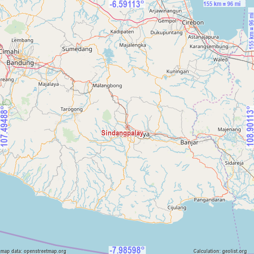
Sindangpalay GPS coordinates[2]
7° 17' 20.76" South, 108° 11' 52.8" East
| Map corner | latitude | longitude |
|---|---|---|
| Upper-left | -6.59113°, | 107.49488° |
| Center: | -7.2891°, | 108.198° |
| Lower-right: | -7.98598°, | 108.90113° |
| Map W x H: | 155.1×155.1 km | = 96.4×96.4mi |
| max Lat: | 5.88969° ⇑48.4% North |
| Sindangpalay: | -7.2891° |
| min Lat: | ⇓51.6% South -10.934° |
| min Long | Sindangpalay | max Long |
| 95.1345° | 108.198° | 140.9419° |
| W 23.4%⇐ | ⇒76.6% E |
Elevation
Elevation of Sindangpalay is 396 m = 1299 ft, and this is 166.3 m = 546 ft above average elevation for this country.
| Max E: |
3185 m = 10449 ft | 22.1% |
| Sindangpalay | 396 m 1299 ft | |
| Avg. | 229.7 m = 754 ft | |
Min E: |
-1 m = -3 ft | 77.9% |
See also: Indonesia elevation on elevation.city.
Geographical zone
Sindangpalay is located in South Torrid zone (between Equator and Tropic of Capricorn). Distance of Equator is 810.5 km =503.6 mi to North.| Distance of | km | miles | from Sindangpalay |
|---|---|---|---|
| Equator | 810.5 | 503.6 | to North |
| Tropic Capricorn | 1795.4 | 1115.6 | to South |
| Antarctic Circle | 6590.7 | 4095.3 | to South |
| South Pole | 9196.6 | 5714.5 | to South |


Nearby cities:
15 places around Sindangpalay: (largest is in red/bold)
• Cisingkah
1.5 km =0.9 mi,  41°
41°
• Gunungbatu
2.6 km =1.6 mi,  165°
165°
• Jati
1.7 km =1.1 mi,  160°
160°
• Kosangka
0.9 km =0.6 mi,  108°
108°
• Leuwidahu
2.2 km =1.4 mi,  140°
140°
• Nagarasari
2.9 km =1.8 mi,  115°
115°
• Pagendingan
2.9 km =1.8 mi,  333°
333°
• Pakemitan
0.4 km =0.2 mi,  151°
151°
• Parakanhonje Wetan
1.1 km =0.7 mi,  338°
338°
• Rajapeni
1.9 km =1.2 mi,  73°
73°
• Sukahaji
2.5 km =1.6 mi,  0°
0°
• Sukamaju Kidul
1.4 km =0.9 mi,  298°
298°
• Sukamulya
1.3 km =0.8 mi,  29°
29°
• Sukamulya
2.9 km =1.8 mi,  190°
190°
• Sukarindik
1.8 km =1.1 mi,  222°
222°
Sources, notices
• [Note1] Compared only with cities in Indonesia existing in our database
• [Src1] Map data: © OpenStreetMap contributors (CC-BY-SA)
• [Src2] Other city data from geonames.org with taken over terms of usage.
• [Src3] Geographical zone / Annual Mean Temperature by Robert A. Rohde @ Wikipedia
