Gunungbatu geodata
Gunungbatu (West Java) is a seat of a fourth-order administrative division; located in Indonesia in Asia/Jakarta (GMT+7) time zone. In our database, there are 407 cities with bigger population. Compared to other cities in Indonesia, 50.6% of cities are located further ↓South; 76.4% of cities are located further →East and 76.6% of cities have lower elevation than Gunungbatu. Note1


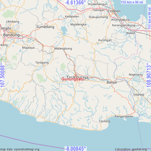
Gunungbatu GPS coordinates[2]
7° 18' 41.76" South, 108° 12' 14.4" East
| Map corner | latitude | longitude |
|---|---|---|
| Upper-left | -6.61366°, | 107.50088° |
| Center: | -7.3116°, | 108.204° |
| Lower-right: | -8.00845°, | 108.90713° |
| Map W x H: | 155.1×155.1 km | = 96.4×96.4mi |
| max Lat: | 5.88969° ⇑49.4% North |
| Gunungbatu: | -7.3116° |
| min Lat: | ⇓50.6% South -10.934° |
| min Long | Gunungbatu | max Long |
| 95.1345° | 108.204° | 140.9419° |
| W 23.6%⇐ | ⇒76.4% E |
Elevation
Elevation of Gunungbatu is 380 m = 1247 ft, and this is 150.3 m = 493 ft above average elevation for this country.
| Max E: |
3185 m = 10449 ft | 23.4% |
| Gunungbatu | 380 m 1247 ft | |
| Avg. | 229.7 m = 754 ft | |
Min E: |
-1 m = -3 ft | 76.6% |
See also: Indonesia elevation on elevation.city.
Geographical zone
Gunungbatu is located in South Torrid zone (between Equator and Tropic of Capricorn). Distance of Equator is 813 km =505.2 mi to North.| Distance of | km | miles | from Gunungbatu |
|---|---|---|---|
| Equator | 813 | 505.2 | to North |
| Tropic Capricorn | 1792.9 | 1114.1 | to South |
| Antarctic Circle | 6588.2 | 4093.7 | to South |
| South Pole | 9194.1 | 5712.9 | to South |


Nearby cities:
15 places around Gunungbatu: (largest is in red/bold)
• Ampera
1.4 km =0.9 mi,  148°
148°
• Argasari
1.5 km =0.9 mi,  172°
172°
• Bantar
2 km =1.2 mi,  230°
230°
• Gunungkoneng
2 km =1.2 mi,  159°
159°
• Jati
0.9 km =0.6 mi,  354°
354°
• Kosangka
2.2 km =1.4 mi,  5°
5°
• Leuwidahu
1.1 km =0.7 mi,  43°
43°
• Mancogeh
1.5 km =0.9 mi,  77°
77°
• Nagarasari
2.3 km =1.4 mi,  56°
56°
• Pakemitan
2.2 km =1.4 mi, 347°
• Rancageneng Satu
2.1 km =1.3 mi,  251°
251°
• Sukamulya
1.3 km =0.8 mi, 253°
• Sukarindik
2.2 km =1.4 mi,  301°
301°
• Tasikmalaya
2.5 km =1.6 mi,  133°
133°
• Tawangsari
2.2 km =1.4 mi,  123°
123°
Sources, notices
• [Note1] Compared only with cities in Indonesia existing in our database
• [Src1] Map data: © OpenStreetMap contributors (CC-BY-SA)
• [Src2] Other city data from geonames.org with taken over terms of usage.
• [Src3] Geographical zone / Annual Mean Temperature by Robert A. Rohde @ Wikipedia
