Pagerageung Tengah geodata
Pagerageung Tengah (West Java) is a seat of a fourth-order administrative division; located in Indonesia in Asia/Jakarta (GMT+7) time zone. In our database, there are 407 cities with bigger population. Compared to other cities in Indonesia, 59.6% of cities are located further ↓South; 77.4% of cities are located further →East and 86.7% of cities have lower elevation than Pagerageung Tengah. Note1


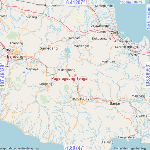
Pagerageung Tengah GPS coordinates[2]
7° 6' 37.08" South, 108° 9' 59.04" East
| Map corner | latitude | longitude |
|---|---|---|
| Upper-left | -6.41207°, | 107.46328° |
| Center: | -7.1103°, | 108.1664° |
| Lower-right: | -7.80747°, | 108.86953° |
| Map W x H: | 155.2×155.2 km | = 96.4×96.4mi |
| max Lat: | 5.88969° ⇑40.4% North |
| Pagerageung Tengah: | -7.1103° |
| min Lat: | ⇓59.6% South -10.934° |
| min Long | Pagerageung Ten | max Long |
| 95.1345° | 108.1664° | 140.9419° |
| W 22.6%⇐ | ⇒77.4% E |
Elevation
Elevation of Pagerageung Tengah is 551 m = 1808 ft, and this is 321.3 m = 1054 ft above average elevation for this country.
| Max E: |
3185 m = 10449 ft | 13.3% |
| Pagerageung Tengah | 551 m 1808 ft | |
| Avg. | 229.7 m = 754 ft | |
Min E: |
-1 m = -3 ft | 86.7% |
See also: Indonesia elevation on elevation.city.
Geographical zone
Pagerageung Tengah is located in South Torrid zone (between Equator and Tropic of Capricorn). Distance of Equator is 790.6 km =491.3 mi to North.| Distance of | km | miles | from Pagerageung Tengah |
|---|---|---|---|
| Equator | 790.6 | 491.3 | to North |
| Tropic Capricorn | 1815.3 | 1128 | to South |
| Antarctic Circle | 6610.6 | 4107.6 | to South |
| South Pole | 9216.5 | 5726.9 | to South |


Nearby cities:
15 places around Pagerageung Tengah: (largest is in red/bold)
• Cijangkar
4.3 km =2.7 mi,  217°
217°
• Cimanglid
2 km =1.2 mi,  112°
112°
• Ciseuti Girang
2.1 km =1.3 mi,  168°
168°
• Citeureup
2.1 km =1.3 mi,  245°
245°
• Guranteng
3.2 km =2 mi,  67°
67°
• Nanggewer
1 km =0.6 mi,  338°
338°
• Pagerageung
0.2 km =0.1 mi, 169°
• Pamoyanan
2.2 km =1.4 mi, 220°
• Puteran Kidul
3.8 km =2.4 mi,  104°
104°
• Rancakuya
4.4 km =2.7 mi,  208°
208°
• Sindangtamu
4.1 km =2.5 mi, 208°
• Sukamaju
2.7 km =1.7 mi,  149°
149°
• Sukapancar
3.9 km =2.4 mi,  155°
155°
• Tagog
3.2 km =2 mi, 248°
• Tanjunghurip
3.6 km =2.2 mi,  184°
184°
Sources, notices
• [Note1] Compared only with cities in Indonesia existing in our database
• [Src1] Map data: © OpenStreetMap contributors (CC-BY-SA)
• [Src2] Other city data from geonames.org with taken over terms of usage.
• [Src3] Geographical zone / Annual Mean Temperature by Robert A. Rohde @ Wikipedia
