Balokang geodata
Balokang (West Java) is a seat of a fourth-order administrative division; located in Indonesia in Asia/Jakarta (GMT+7) time zone. In our database, there are 407 cities with bigger population. Compared to other cities in Indonesia, 52% of cities are located further ↑North; 71.7% of cities are located further →East and 53.2% of cities have lower elevation than Balokang. Note1


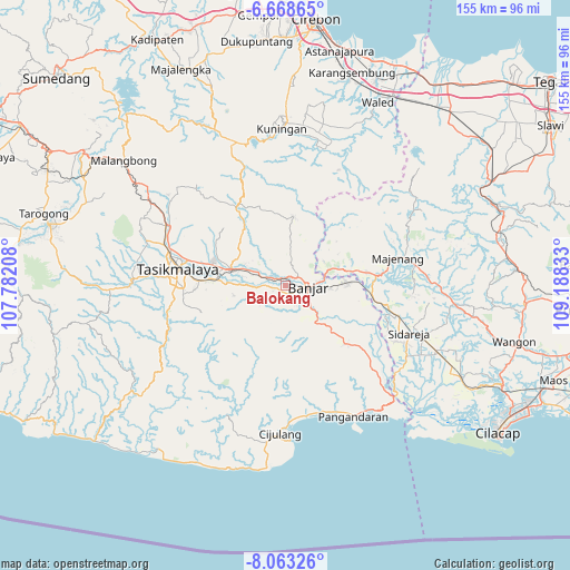
Balokang GPS coordinates[2]
7° 21' 59.4" South, 108° 29' 6.72" East
| Map corner | latitude | longitude |
|---|---|---|
| Upper-left | -6.66865°, | 107.78208° |
| Center: | -7.3665°, | 108.4852° |
| Lower-right: | -8.06326°, | 109.18833° |
| Map W x H: | 155.1×155.1 km | = 96.4×96.4mi |
| max Lat: | 5.88969° ⇑52% North |
| Balokang: | -7.3665° |
| min Lat: | ⇓48% South -10.934° |
| min Long | Balokang | max Long |
| 95.1345° | 108.4852° | 140.9419° |
| W 28.3%⇐ | ⇒71.7% E |
Elevation
Elevation of Balokang is 115 m = 377 ft, and this is 114.7 m = 376 ft below average elevation for this country.
| Max E: |
3185 m = 10449 ft | 46.8% |
| Avg. | 229.7 m = 754 ft | |
| Balokang | 115 m = 377 ft | |
Min E: |
-1 m = -3 ft | 53.2% |
See also: Indonesia elevation on elevation.city.
Geographical zone
Balokang is located in South Torrid zone (between Equator and Tropic of Capricorn). Distance of Equator is 819.1 km =509 mi to North.| Distance of | km | miles | from Balokang |
|---|---|---|---|
| Equator | 819.1 | 509 | to North |
| Tropic Capricorn | 1786.8 | 1110.3 | to South |
| Antarctic Circle | 6582.1 | 4089.9 | to South |
| South Pole | 9188 | 5709.2 | to South |


Nearby cities:
15 places around Balokang: (largest is in red/bold)
• Banjar
5.3 km =3.3 mi,  92°
92°
• Bojong
2.4 km =1.5 mi,  155°
155°
• Bojongmalang
4.3 km =2.7 mi,  214°
214°
• Cibeta
2.2 km =1.4 mi,  323°
323°
• Cibeulah
5.6 km =3.5 mi,  339°
339°
• Cibeureum
2.6 km =1.6 mi,  100°
100°
• Cilangkap
4.4 km =2.7 mi, 161°
• Cimaragas
2.5 km =1.6 mi,  256°
256°
• Cisaga
4.1 km =2.5 mi,  56°
56°
• Kepel
3.2 km =2 mi,  2°
2°
• Pasirnangka
5.3 km =3.3 mi,  271°
271°
• Raksabaya
3.6 km =2.2 mi,  244°
244°
• Sembungjaya
3.2 km =2 mi,  53°
53°
• Tenjolaya
4.8 km =3 mi,  9°
9°
• Warungbuah
3 km =1.9 mi,  135°
135°
Sources, notices
• [Note1] Compared only with cities in Indonesia existing in our database
• [Src1] Map data: © OpenStreetMap contributors (CC-BY-SA)
• [Src2] Other city data from geonames.org with taken over terms of usage.
• [Src3] Geographical zone / Annual Mean Temperature by Robert A. Rohde @ Wikipedia
