Kepel geodata
Kepel (West Java) is a seat of a fourth-order administrative division; located in Indonesia in Asia/Jakarta (GMT+7) time zone. In our database, there are 407 cities with bigger population. Compared to other cities in Indonesia, 50.7% of cities are located further ↑North; 71.7% of cities are located further →East and 51.4% of cities have higher elevation than Kepel. Note1


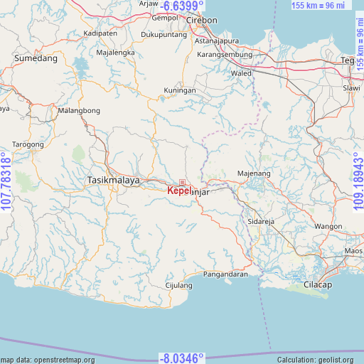
Kepel GPS coordinates[2]
7° 20' 16.08" South, 108° 29' 10.68" East
| Map corner | latitude | longitude |
|---|---|---|
| Upper-left | -6.6399°, | 107.78318° |
| Center: | -7.3378°, | 108.4863° |
| Lower-right: | -8.0346°, | 109.18943° |
| Map W x H: | 155.1×155.1 km | = 96.4×96.4mi |
| max Lat: | 5.88969° ⇑50.7% North |
| Kepel: | -7.3378° |
| min Lat: | ⇓49.3% South -10.934° |
| min Long | Kepel | max Long |
| 95.1345° | 108.4863° | 140.9419° |
| W 28.3%⇐ | ⇒71.7% E |
Elevation
Elevation of Kepel is 97 m = 318 ft, and this is 132.7 m = 435 ft below average elevation for this country.
| Max E: |
3185 m = 10449 ft | 51.4% |
| Avg. | 229.7 m = 754 ft | |
| Kepel | 97 m = 318 ft | |
Min E: |
-1 m = -3 ft | 48.6% |
See also: Indonesia elevation on elevation.city.
Geographical zone
Kepel is located in South Torrid zone (between Equator and Tropic of Capricorn). Distance of Equator is 815.9 km =507 mi to North.| Distance of | km | miles | from Kepel |
|---|---|---|---|
| Equator | 815.9 | 507 | to North |
| Tropic Capricorn | 1790 | 1112.3 | to South |
| Antarctic Circle | 6585.3 | 4091.9 | to South |
| South Pole | 9191.2 | 5711.1 | to South |


Nearby cities:
15 places around Kepel: (largest is in red/bold)
• Balokang
3.2 km =2 mi,  182°
182°
• Bojong
5.4 km =3.4 mi,  170°
170°
• Cempaka
3.7 km =2.3 mi,  64°
64°
• Cibeta
2 km =1.2 mi,  226°
226°
• Cibeulah
2.9 km =1.8 mi,  314°
314°
• Cibeureum
4.4 km =2.7 mi,  145°
145°
• Cimaragas
4.6 km =2.9 mi,  214°
214°
• Cisaga
3.4 km =2.1 mi,  105°
105°
• Dusun Desa Bunter
5.7 km =3.5 mi,  337°
337°
• Kertabumi
5.3 km =3.3 mi,  273°
273°
• Raksabaya
5.8 km =3.6 mi,  215°
215°
• Sembungjaya
2.7 km =1.7 mi,  117°
117°
• Sukaharja
4.1 km =2.5 mi,  292°
292°
• Tenjolaya
1.7 km =1.1 mi,  21°
21°
• Warungbuah
5.7 km =3.5 mi,  159°
159°
Sources, notices
• [Note1] Compared only with cities in Indonesia existing in our database
• [Src1] Map data: © OpenStreetMap contributors (CC-BY-SA)
• [Src2] Other city data from geonames.org with taken over terms of usage.
• [Src3] Geographical zone / Annual Mean Temperature by Robert A. Rohde @ Wikipedia
