Jagabaya Dua geodata
Jagabaya Dua (West Java) is a seat of a fourth-order administrative division; located in Indonesia in Asia/Jakarta (GMT+7) time zone. In our database, there are 407 cities with bigger population. Compared to other cities in Indonesia, 59.9% of cities are located further ↓South; 73% of cities are located further →East and 85.5% of cities have lower elevation than Jagabaya Dua. Note1


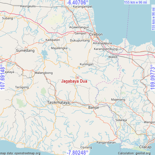
Jagabaya Dua GPS coordinates[2]
7° 6' 19.08" South, 108° 23' 40.56" East
| Map corner | latitude | longitude |
|---|---|---|
| Upper-left | -6.40706°, | 107.69148° |
| Center: | -7.1053°, | 108.3946° |
| Lower-right: | -7.80248°, | 109.09773° |
| Map W x H: | 155.2×155.2 km | = 96.4×96.4mi |
| max Lat: | 5.88969° ⇑40.1% North |
| Jagabaya Dua: | -7.1053° |
| min Lat: | ⇓59.9% South -10.934° |
| min Long | Jagabaya Dua | max Long |
| 95.1345° | 108.3946° | 140.9419° |
| W 27%⇐ | ⇒73% E |
Elevation
Elevation of Jagabaya Dua is 527 m = 1729 ft, and this is 297.3 m = 975 ft above average elevation for this country.
| Max E: |
3185 m = 10449 ft | 14.5% |
| Jagabaya Dua | 527 m 1729 ft | |
| Avg. | 229.7 m = 754 ft | |
Min E: |
-1 m = -3 ft | 85.5% |
See also: Indonesia elevation on elevation.city.
Geographical zone
Jagabaya Dua is located in South Torrid zone (between Equator and Tropic of Capricorn). Distance of Equator is 790 km =490.9 mi to North.| Distance of | km | miles | from Jagabaya Dua |
|---|---|---|---|
| Equator | 790 | 490.9 | to North |
| Tropic Capricorn | 1815.9 | 1128.3 | to South |
| Antarctic Circle | 6611.1 | 4107.9 | to South |
| South Pole | 9217 | 5727.2 | to South |


Nearby cities:
15 places around Jagabaya Dua: (largest is in red/bold)
• Babakan
4.5 km =2.8 mi,  69°
69°
• Bojong
4.8 km =3 mi,  104°
104°
• Bojongsari
4.1 km =2.5 mi,  344°
344°
• Cantilan
4.8 km =3 mi,  89°
89°
• Cigeur
5.5 km =3.4 mi,  5°
5°
• Cimenga
2.5 km =1.6 mi,  20°
20°
• Cinyasag
2.8 km =1.7 mi,  303°
303°
• Emblegan
4.2 km =2.6 mi,  135°
135°
• Gardu
3.4 km =2.1 mi, 340°
• Kaom
3.6 km =2.2 mi, 138°
• Legok Satu
3.9 km =2.4 mi,  261°
261°
• Madura
5 km =3.1 mi,  200°
200°
• Panawangan
2 km =1.2 mi,  225°
225°
• Sagalaherang
1.7 km =1.1 mi,  181°
181°
• Wedangtemu
3.8 km =2.4 mi,  358°
358°
Sources, notices
• [Note1] Compared only with cities in Indonesia existing in our database
• [Src1] Map data: © OpenStreetMap contributors (CC-BY-SA)
• [Src2] Other city data from geonames.org with taken over terms of usage.
• [Src3] Geographical zone / Annual Mean Temperature by Robert A. Rohde @ Wikipedia
