Kaom geodata
Kaom (West Java) is a seat of a fourth-order administrative division; located in Indonesia in Asia/Jakarta (GMT+7) time zone. In our database, there are 407 cities with bigger population. Compared to other cities in Indonesia, 58.6% of cities are located further ↓South; 72.7% of cities are located further →East and 84.4% of cities have lower elevation than Kaom. Note1


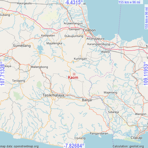
Kaom GPS coordinates[2]
7° 7' 46.92" South, 108° 24' 59.04" East
| Map corner | latitude | longitude |
|---|---|---|
| Upper-left | -6.4315°, | 107.71328° |
| Center: | -7.1297°, | 108.4164° |
| Lower-right: | -7.82684°, | 109.11953° |
| Map W x H: | 155.1×155.2 km | = 96.4×96.4mi |
| max Lat: | 5.88969° ⇑41.4% North |
| Kaom: | -7.1297° |
| min Lat: | ⇓58.6% South -10.934° |
| min Long | Kaom | max Long |
| 95.1345° | 108.4164° | 140.9419° |
| W 27.3%⇐ | ⇒72.7% E |
Elevation
Elevation of Kaom is 507 m = 1663 ft, and this is 277.3 m = 910 ft above average elevation for this country.
| Max E: |
3185 m = 10449 ft | 15.6% |
| Kaom | 507 m 1663 ft | |
| Avg. | 229.7 m = 754 ft | |
Min E: |
-1 m = -3 ft | 84.4% |
See also: Indonesia elevation on elevation.city.
Geographical zone
Kaom is located in South Torrid zone (between Equator and Tropic of Capricorn). Distance of Equator is 792.7 km =492.6 mi to North.| Distance of | km | miles | from Kaom |
|---|---|---|---|
| Equator | 792.7 | 492.6 | to North |
| Tropic Capricorn | 1813.2 | 1126.7 | to South |
| Antarctic Circle | 6608.4 | 4106.3 | to South |
| South Pole | 9214.3 | 5725.5 | to South |


Nearby cities:
15 places around Kaom: (largest is in red/bold)
• Babakan
4.6 km =2.9 mi,  23°
23°
• Bojong
2.7 km =1.7 mi,  56°
56°
• Cantilan
3.7 km =2.3 mi,  41°
41°
• Cibeuruy
2.7 km =1.7 mi,  141°
141°
• Cicadas
3 km =1.9 mi,  174°
174°
• Emblegan
0.6 km =0.4 mi,  120°
120°
• Jagabaya Dua
3.6 km =2.2 mi,  318°
318°
• Jatinagara Kulon
4.7 km =2.9 mi,  176°
176°
• Madura
4.6 km =2.9 mi,  244°
244°
• Mekarjaya
5 km =3.1 mi,  131°
131°
• Pabuaran
4.8 km =3 mi,  151°
151°
• Panawangan
4.1 km =2.5 mi,  288°
288°
• Pasiramis
4.5 km =2.8 mi,  205°
205°
• Sagalaherang
2.7 km =1.7 mi, 293°
• Tigaherang
3.2 km =2 mi,  89°
89°
Sources, notices
• [Note1] Compared only with cities in Indonesia existing in our database
• [Src1] Map data: © OpenStreetMap contributors (CC-BY-SA)
• [Src2] Other city data from geonames.org with taken over terms of usage.
• [Src3] Geographical zone / Annual Mean Temperature by Robert A. Rohde @ Wikipedia
