Plalangan geodata
Plalangan (Central Java) is a seat of a fourth-order administrative division; located in Indonesia in Asia/Jakarta (GMT+7) time zone. In our database, there are 407 cities with bigger population. Compared to other cities in Indonesia, 78% of cities are located further ↓South; 62.5% of cities are located further →East and 72.7% of cities have higher elevation than Plalangan. Note1


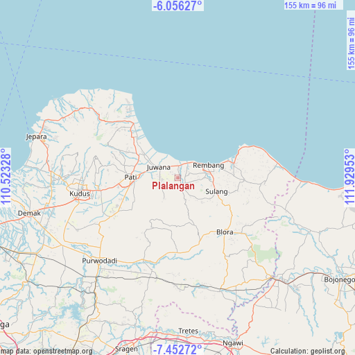
Plalangan GPS coordinates[2]
6° 45' 18" South, 111° 13' 35.04" East
| Map corner | latitude | longitude |
|---|---|---|
| Upper-left | -6.05627°, | 110.52328° |
| Center: | -6.755°, | 111.2264° |
| Lower-right: | -7.45272°, | 111.92953° |
| Map W x H: | 155.3×155.3 km | = 96.5×96.5mi |
| max Lat: | 5.88969° ⇑22% North |
| Plalangan: | -6.755° |
| min Lat: | ⇓78% South -10.934° |
| min Long | Plalangan | max Long |
| 95.1345° | 111.2264° | 140.9419° |
| W 37.5%⇐ | ⇒62.5% E |
Elevation
Elevation of Plalangan is 28 m = 92 ft, and this is 201.7 m = 662 ft below average elevation for this country.
| Max E: |
3185 m = 10449 ft | 72.7% |
| Avg. | 229.7 m = 754 ft | |
| Plalangan | 28 m = 92 ft | |
Min E: |
-1 m = -3 ft | 27.3% |
See also: Indonesia elevation on elevation.city.
Geographical zone
Plalangan is located in South Torrid zone (between Equator and Tropic of Capricorn). Distance of Equator is 751.1 km =466.7 mi to North.| Distance of | km | miles | from Plalangan |
|---|---|---|---|
| Equator | 751.1 | 466.7 | to North |
| Tropic Capricorn | 1854.8 | 1152.5 | to South |
| Antarctic Circle | 6650.1 | 4132.2 | to South |
| South Pole | 9256 | 5751.4 | to South |


Nearby cities:
15 places around Plalangan: (largest is in red/bold)
• Gunungsari
2.8 km =1.7 mi,  18°
18°
• Jemblem
1.6 km =1 mi,  67°
67°
• Kalimati
1.4 km =0.9 mi,  107°
107°
• Kuniran
1.4 km =0.9 mi,  25°
25°
• Ledok
3.3 km =2.1 mi, 20°
• Lundo
3.3 km =2.1 mi,  235°
235°
• Maguan
2 km =1.2 mi,  42°
42°
• Majasem
3.4 km =2.1 mi,  104°
104°
• Manjang Kidul
2.9 km =1.8 mi,  141°
141°
• Ngulakan
2.4 km =1.5 mi,  184°
184°
• Pagak Kulon
1.3 km =0.8 mi,  253°
253°
• Sobo
1.9 km =1.2 mi,  221°
221°
• Taunan
2.5 km =1.6 mi,  207°
207°
• Trolu
2 km =1.2 mi,  319°
319°
• Wiroto
3.2 km =2 mi, 95°
Sources, notices
• [Note1] Compared only with cities in Indonesia existing in our database
• [Src1] Map data: © OpenStreetMap contributors (CC-BY-SA)
• [Src2] Other city data from geonames.org with taken over terms of usage.
• [Src3] Geographical zone / Annual Mean Temperature by Robert A. Rohde @ Wikipedia
