Lundo geodata
Lundo (Central Java) is a seat of a fourth-order administrative division; located in Indonesia in Asia/Jakarta (GMT+7) time zone. In our database, there are 407 cities with bigger population. Compared to other cities in Indonesia, 77.4% of cities are located further ↓South; 62.6% of cities are located further →East and 74.1% of cities have higher elevation than Lundo. Note1


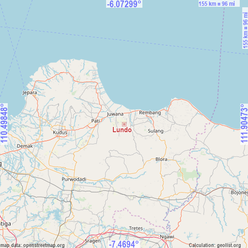
Lundo GPS coordinates[2]
6° 46' 18.12" South, 111° 12' 5.76" East
| Map corner | latitude | longitude |
|---|---|---|
| Upper-left | -6.07299°, | 110.49848° |
| Center: | -6.7717°, | 111.2016° |
| Lower-right: | -7.4694°, | 111.90473° |
| Map W x H: | 155.3×155.3 km | = 96.5×96.5mi |
| max Lat: | 5.88969° ⇑22.6% North |
| Lundo: | -6.7717° |
| min Lat: | ⇓77.4% South -10.934° |
| min Long | Lundo | max Long |
| 95.1345° | 111.2016° | 140.9419° |
| W 37.4%⇐ | ⇒62.6% E |
Elevation
Elevation of Lundo is 26 m = 85 ft, and this is 203.7 m = 668 ft below average elevation for this country.
| Max E: |
3185 m = 10449 ft | 74.1% |
| Avg. | 229.7 m = 754 ft | |
| Lundo | 26 m = 85 ft | |
Min E: |
-1 m = -3 ft | 25.9% |
See also: Indonesia elevation on elevation.city.
Geographical zone
Lundo is located in South Torrid zone (between Equator and Tropic of Capricorn). Distance of Equator is 752.9 km =467.8 mi to North.| Distance of | km | miles | from Lundo |
|---|---|---|---|
| Equator | 752.9 | 467.8 | to North |
| Tropic Capricorn | 1853 | 1151.4 | to South |
| Antarctic Circle | 6648.2 | 4131 | to South |
| South Pole | 9254.1 | 5750.2 | to South |


Nearby cities:
15 places around Lundo: (largest is in red/bold)
• Blingi
1.8 km =1.1 mi,  262°
262°
• Gendolo
3.2 km =2 mi,  191°
191°
• Kebonturi
2.4 km =1.5 mi,  306°
306°
• Kemangi
1.5 km =0.9 mi,  210°
210°
• Legok
3 km =1.9 mi,  342°
342°
• Mojolampir
3.2 km =2 mi,  165°
165°
• Ngulakan
2.6 km =1.6 mi,  100°
100°
• Pagak Kulon
2.1 km =1.3 mi,  45°
45°
• Plalangan
3.3 km =2.1 mi,  55°
55°
• Plosojenar
3.7 km =2.3 mi, 313°
• Sobo
1.5 km =0.9 mi,  73°
73°
• Sumberan
2.2 km =1.4 mi, 174°
• Taunan
1.6 km =1 mi, 103°
• Trolu
3.7 km =2.3 mi,  23°
23°
• Wungwung
3.8 km =2.4 mi,  145°
145°
Sources, notices
• [Note1] Compared only with cities in Indonesia existing in our database
• [Src1] Map data: © OpenStreetMap contributors (CC-BY-SA)
• [Src2] Other city data from geonames.org with taken over terms of usage.
• [Src3] Geographical zone / Annual Mean Temperature by Robert A. Rohde @ Wikipedia
