Maguan geodata
Maguan (Central Java) is a seat of a fourth-order administrative division; located in Indonesia in Asia/Jakarta (GMT+7) time zone. In our database, there are 407 cities with bigger population. Compared to other cities in Indonesia, 78.6% of cities are located further ↓South; 62.3% of cities are located further →East and 79.9% of cities have higher elevation than Maguan. Note1


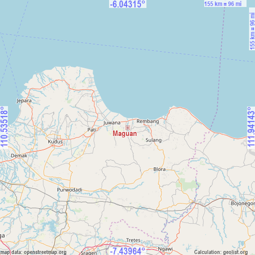
Maguan GPS coordinates[2]
6° 44' 30.84" South, 111° 14' 17.88" East
| Map corner | latitude | longitude |
|---|---|---|
| Upper-left | -6.04315°, | 110.53518° |
| Center: | -6.7419°, | 111.2383° |
| Lower-right: | -7.43964°, | 111.94143° |
| Map W x H: | 155.3×155.3 km | = 96.5×96.5mi |
| max Lat: | 5.88969° ⇑21.4% North |
| Maguan: | -6.7419° |
| min Lat: | ⇓78.6% South -10.934° |
| min Long | Maguan | max Long |
| 95.1345° | 111.2383° | 140.9419° |
| W 37.7%⇐ | ⇒62.3% E |
Elevation
Elevation of Maguan is 19 m = 62 ft, and this is 210.7 m = 691 ft below average elevation for this country.
| Max E: |
3185 m = 10449 ft | 79.9% |
| Avg. | 229.7 m = 754 ft | |
| Maguan | 19 m = 62 ft | |
Min E: |
-1 m = -3 ft | 20.1% |
See also: Indonesia elevation on elevation.city.
Geographical zone
Maguan is located in South Torrid zone (between Equator and Tropic of Capricorn). Distance of Equator is 749.6 km =465.8 mi to North.| Distance of | km | miles | from Maguan |
|---|---|---|---|
| Equator | 749.6 | 465.8 | to North |
| Tropic Capricorn | 1856.3 | 1153.5 | to South |
| Antarctic Circle | 6651.5 | 4133 | to South |
| South Pole | 9257.4 | 5752.3 | to South |


Nearby cities:
15 places around Maguan: (largest is in red/bold)
• Batangan
3.7 km =2.3 mi,  344°
344°
• Gingsir
3.3 km =2.1 mi,  89°
89°
• Gunungsari
1.3 km =0.8 mi, 340°
• Jemblem
0.9 km =0.6 mi,  171°
171°
• Kalimati
1.9 km =1.2 mi,  180°
180°
• Kedalon
2.6 km =1.6 mi,  330°
330°
• Kuniran
0.7 km =0.4 mi,  254°
254°
• Ledok
1.7 km =1.1 mi,  355°
355°
• Majasem
3 km =1.9 mi,  139°
139°
• Manjang Kidul
3.7 km =2.3 mi, 172°
• Pagak Kulon
3.1 km =1.9 mi,  234°
234°
• Plalangan
2 km =1.2 mi,  222°
222°
• Sambiyan
3.7 km =2.3 mi,  71°
71°
• Trolu
2.6 km =1.6 mi,  270°
270°
• Wiroto
2.6 km =1.6 mi,  132°
132°
Sources, notices
• [Note1] Compared only with cities in Indonesia existing in our database
• [Src1] Map data: © OpenStreetMap contributors (CC-BY-SA)
• [Src2] Other city data from geonames.org with taken over terms of usage.
• [Src3] Geographical zone / Annual Mean Temperature by Robert A. Rohde @ Wikipedia
