Rendole geodata
Rendole (Central Java) is a seat of a fourth-order administrative division; located in Indonesia in Asia/Jakarta (GMT+7) time zone. In our database, there are 407 cities with bigger population. Compared to other cities in Indonesia, 79% of cities are located further ↓South; 64.8% of cities are located further →East and 65.2% of cities have higher elevation than Rendole. Note1


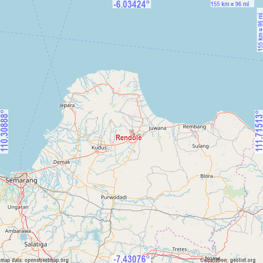
Rendole GPS coordinates[2]
6° 43' 58.8" South, 111° 0' 43.2" East
| Map corner | latitude | longitude |
|---|---|---|
| Upper-left | -6.03424°, | 110.30888° |
| Center: | -6.733°, | 111.012° |
| Lower-right: | -7.43076°, | 111.71513° |
| Map W x H: | 155.3×155.3 km | = 96.5×96.5mi |
| max Lat: | 5.88969° ⇑21% North |
| Rendole: | -6.733° |
| min Lat: | ⇓79% South -10.934° |
| min Long | Rendole | max Long |
| 95.1345° | 111.012° | 140.9419° |
| W 35.2%⇐ | ⇒64.8% E |
Elevation
Elevation of Rendole is 42 m = 138 ft, and this is 187.7 m = 616 ft below average elevation for this country.
| Max E: |
3185 m = 10449 ft | 65.2% |
| Avg. | 229.7 m = 754 ft | |
| Rendole | 42 m = 138 ft | |
Min E: |
-1 m = -3 ft | 34.8% |
See also: Indonesia elevation on elevation.city.
Geographical zone
Rendole is located in South Torrid zone (between Equator and Tropic of Capricorn). Distance of Equator is 748.6 km =465.2 mi to North.| Distance of | km | miles | from Rendole |
|---|---|---|---|
| Equator | 748.6 | 465.2 | to North |
| Tropic Capricorn | 1857.3 | 1154.1 | to South |
| Antarctic Circle | 6652.5 | 4133.7 | to South |
| South Pole | 9258.4 | 5752.9 | to South |


Nearby cities:
15 places around Rendole: (largest is in red/bold)
• Bringin
3.3 km =2.1 mi,  42°
42°
• Gemiring
2.3 km =1.4 mi,  170°
170°
• Jambean
2.6 km =1.6 mi,  100°
100°
• Kaborongan
3.4 km =2.1 mi,  115°
115°
• Karangdowo
3.5 km =2.2 mi, 98°
• Karangnongko
1.9 km =1.2 mi,  28°
28°
• Ngarus
2.5 km =1.6 mi,  109°
109°
• Parenggan
3.8 km =2.4 mi, 114°
• Pati
3.8 km =2.4 mi,  131°
131°
• Puri
2.3 km =1.4 mi,  139°
139°
• Purwosari
3.7 km =2.3 mi,  342°
342°
• Randangan
3.7 km =2.3 mi,  318°
318°
• Tlogorejo
2.6 km =1.6 mi,  11°
11°
• Tlogowungu
2.9 km =1.8 mi,  4°
4°
• Winong
2.4 km =1.5 mi, 122°
Sources, notices
• [Note1] Compared only with cities in Indonesia existing in our database
• [Src1] Map data: © OpenStreetMap contributors (CC-BY-SA)
• [Src2] Other city data from geonames.org with taken over terms of usage.
• [Src3] Geographical zone / Annual Mean Temperature by Robert A. Rohde @ Wikipedia
