Pati geodata
Pati (Central Java) is a seat of a second-order administrative division; located in Indonesia in Asia/Jakarta (GMT+7) time zone. With population of 122,785 people, there are 107 cities with bigger population in this country. Compared to other cities in Indonesia, 78% of cities are located further ↓South; 64.5% of cities are located further →East and 86.4% of cities have higher elevation than Pati. Note1


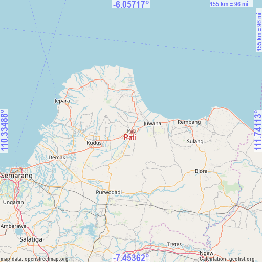
Pati GPS coordinates[2]
6° 45' 21.24" South, 111° 2' 16.8" East
| Map corner | latitude | longitude |
|---|---|---|
| Upper-left | -6.05717°, | 110.33488° |
| Center: | -6.7559°, | 111.038° |
| Lower-right: | -7.45362°, | 111.74113° |
| Map W x H: | 155.3×155.3 km | = 96.5×96.5mi |
| max Lat: | 5.88969° ⇑22% North |
| Pati: | -6.7559° |
| min Lat: | ⇓78% South -10.934° |
| min Long | Pati | max Long |
| 95.1345° | 111.038° | 140.9419° |
| W 35.5%⇐ | ⇒64.5% E |
Elevation
Elevation of Pati is 13 m = 43 ft, and this is 216.7 m = 711 ft below average elevation for this country.
| Max E: |
3185 m = 10449 ft | 86.4% |
| Avg. | 229.7 m = 754 ft | |
| Pati | 13 m = 43 ft | |
Min E: |
-1 m = -3 ft | 13.6% |
See also: Pati elevation on elevation.city.
Geographical zone
Pati is located in South Torrid zone (between Equator and Tropic of Capricorn). Distance of Equator is 751.2 km =466.8 mi to North.| Distance of | km | miles | from Pati |
|---|---|---|---|
| Equator | 751.2 | 466.8 | to North |
| Tropic Capricorn | 1854.7 | 1152.5 | to South |
| Antarctic Circle | 6650 | 4132.1 | to South |
| South Pole | 9255.9 | 5751.3 | to South |


Nearby cities:
15 places around Pati: (largest is in red/bold)
• Baran
1.6 km =1 mi,  82°
82°
• Bongsri
3.3 km =2.1 mi,  21°
21°
• Gemiring
2.5 km =1.6 mi,  277°
277°
• Geritan
2.5 km =1.6 mi, 80°
• Jambean
2.1 km =1.3 mi,  351°
351°
• Kaborongan
1.1 km =0.7 mi,  8°
8°
• Karangdowo
2.1 km =1.3 mi, 16°
• Krajan Gajahmati
1.1 km =0.7 mi,  126°
126°
• Lambangan
3.4 km =2.1 mi,  74°
74°
• Ngarus
1.8 km =1.1 mi,  342°
342°
• Parenggan
1.1 km =0.7 mi,  28°
28°
• Puri
1.6 km =1 mi,  299°
299°
• Rendole
3.8 km =2.4 mi,  311°
311°
• Sarirejo
1.7 km =1.1 mi,  55°
55°
• Winong
1.5 km =0.9 mi,  326°
326°
Sources, notices
• [Note1] Compared only with cities in Indonesia existing in our database
• [Src1] Map data: © OpenStreetMap contributors (CC-BY-SA)
• [Src2] Other city data from geonames.org with taken over terms of usage.
• [Src3] Geographical zone / Annual Mean Temperature by Robert A. Rohde @ Wikipedia
