Sambiyan geodata
Sambiyan (Central Java) is a seat of a fourth-order administrative division; located in Indonesia in Asia/Jakarta (GMT+7) time zone. In our database, there are 407 cities with bigger population. Compared to other cities in Indonesia, 79.1% of cities are located further ↓South; 62% of cities are located further →East and 86.4% of cities have higher elevation than Sambiyan. Note1


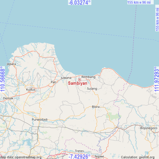
Sambiyan GPS coordinates[2]
6° 43' 53.4" South, 111° 16' 11.28" East
| Map corner | latitude | longitude |
|---|---|---|
| Upper-left | -6.03274°, | 110.56668° |
| Center: | -6.7315°, | 111.2698° |
| Lower-right: | -7.42926°, | 111.97293° |
| Map W x H: | 155.3×155.3 km | = 96.5×96.5mi |
| max Lat: | 5.88969° ⇑20.9% North |
| Sambiyan: | -6.7315° |
| min Lat: | ⇓79.1% South -10.934° |
| min Long | Sambiyan | max Long |
| 95.1345° | 111.2698° | 140.9419° |
| W 38%⇐ | ⇒62% E |
Elevation
Elevation of Sambiyan is 13 m = 43 ft, and this is 216.7 m = 711 ft below average elevation for this country.
| Max E: |
3185 m = 10449 ft | 86.4% |
| Avg. | 229.7 m = 754 ft | |
| Sambiyan | 13 m = 43 ft | |
Min E: |
-1 m = -3 ft | 13.6% |
See also: Indonesia elevation on elevation.city.
Geographical zone
Sambiyan is located in South Torrid zone (between Equator and Tropic of Capricorn). Distance of Equator is 748.5 km =465.1 mi to North.| Distance of | km | miles | from Sambiyan |
|---|---|---|---|
| Equator | 748.5 | 465.1 | to North |
| Tropic Capricorn | 1857.4 | 1154.1 | to South |
| Antarctic Circle | 6652.7 | 4133.8 | to South |
| South Pole | 9258.6 | 5753 | to South |


Nearby cities:
15 places around Sambiyan: (largest is in red/bold)
• Babadan
3 km =1.9 mi,  68°
68°
• Banggi
2.9 km =1.8 mi,  126°
126°
• Dresi Kulon
2.3 km =1.4 mi,  357°
357°
• Dresi Wetan
2.2 km =1.4 mi,  19°
19°
• Gingsir
1.1 km =0.7 mi,  187°
187°
• Jemblem
3.9 km =2.4 mi,  238°
238°
• Karangsekar
3.7 km =2.3 mi,  51°
51°
• Kuangsan
3.6 km =2.2 mi,  116°
116°
• Ledok
3.7 km =2.3 mi,  278°
278°
• Maguan
3.7 km =2.3 mi,  251°
251°
• Majasem
3.8 km =2.4 mi,  204°
204°
• Mojo
2.7 km =1.7 mi,  327°
327°
• Mojogajeh
3.7 km =2.3 mi,  167°
167°
• Pengkol
2.5 km =1.6 mi,  96°
96°
• Wiroto
3.3 km =2.1 mi,  208°
208°
Sources, notices
• [Note1] Compared only with cities in Indonesia existing in our database
• [Src1] Map data: © OpenStreetMap contributors (CC-BY-SA)
• [Src2] Other city data from geonames.org with taken over terms of usage.
• [Src3] Geographical zone / Annual Mean Temperature by Robert A. Rohde @ Wikipedia
