Cileungsir geodata
Cileungsir (West Java) is a seat of a fourth-order administrative division; located in Indonesia in Asia/Jakarta (GMT+7) time zone. In our database, there are 407 cities with bigger population. Compared to other cities in Indonesia, 54.9% of cities are located further ↓South; 71.6% of cities are located further →East and 75% of cities have lower elevation than Cileungsir. Note1


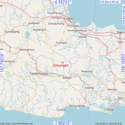
Cileungsir GPS coordinates[2]
7° 12' 18.36" South, 108° 29' 22.2" East
| Map corner | latitude | longitude |
|---|---|---|
| Upper-left | -6.50701°, | 107.78638° |
| Center: | -7.2051°, | 108.4895° |
| Lower-right: | -7.90212°, | 109.19263° |
| Map W x H: | 155.1×155.1 km | = 96.4×96.4mi |
| max Lat: | 5.88969° ⇑45.1% North |
| Cileungsir: | -7.2051° |
| min Lat: | ⇓54.9% South -10.934° |
| min Long | Cileungsir | max Long |
| 95.1345° | 108.4895° | 140.9419° |
| W 28.4%⇐ | ⇒71.6% E |
Elevation
Elevation of Cileungsir is 359 m = 1178 ft, and this is 129.3 m = 424 ft above average elevation for this country.
| Max E: |
3185 m = 10449 ft | 25% |
| Cileungsir | 359 m 1178 ft | |
| Avg. | 229.7 m = 754 ft | |
Min E: |
-1 m = -3 ft | 75% |
See also: Indonesia elevation on elevation.city.
Geographical zone
Cileungsir is located in South Torrid zone (between Equator and Tropic of Capricorn). Distance of Equator is 801.1 km =497.8 mi to North.| Distance of | km | miles | from Cileungsir |
|---|---|---|---|
| Equator | 801.1 | 497.8 | to North |
| Tropic Capricorn | 1804.8 | 1121.5 | to South |
| Antarctic Circle | 6600 | 4101 | to South |
| South Pole | 9205.9 | 5720.3 | to South |


Nearby cities:
15 places around Cileungsir: (largest is in red/bold)
• Bantardendang
5 km =3.1 mi,  25°
25°
• Cikuda
6.5 km =4 mi,  156°
156°
• Dadiharja
6.3 km =3.9 mi,  20°
20°
• Garunggang
5.2 km =3.2 mi,  270°
270°
• Harjamukti
3.2 km =2 mi,  121°
121°
• Karangpari
4.3 km =2.7 mi,  196°
196°
• Kawunglarang
4.5 km =2.8 mi,  351°
351°
• Kiarapayung
2.8 km =1.7 mi,  252°
252°
• Nangela
5.1 km =3.2 mi,  91°
91°
• Rancah
1.9 km =1.2 mi,  60°
60°
• Samarang
5.6 km =3.5 mi, 116°
• Sitularang Landeuh
2.6 km =1.6 mi, 87°
• Sukaharja
6 km =3.7 mi, 346°
• Tangkolo
5.6 km =3.5 mi, 24°
• Tanjungjaya
5.1 km =3.2 mi,  307°
307°
Sources, notices
• [Note1] Compared only with cities in Indonesia existing in our database
• [Src1] Map data: © OpenStreetMap contributors (CC-BY-SA)
• [Src2] Other city data from geonames.org with taken over terms of usage.
• [Src3] Geographical zone / Annual Mean Temperature by Robert A. Rohde @ Wikipedia
