Pengkolrejo geodata
Pengkolrejo (Central Java) is a seat of a fourth-order administrative division; located in Indonesia in Asia/Jakarta (GMT+7) time zone. In our database, there are 407 cities with bigger population. Compared to other cities in Indonesia, 69% of cities are located further ↓South; 61.4% of cities are located further →East and 53.4% of cities have higher elevation than Pengkolrejo. Note1


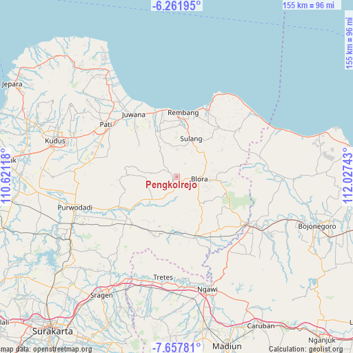
Pengkolrejo GPS coordinates[2]
6° 57' 37.44" South, 111° 19' 27.48" East
| Map corner | latitude | longitude |
|---|---|---|
| Upper-left | -6.26195°, | 110.62118° |
| Center: | -6.9604°, | 111.3243° |
| Lower-right: | -7.65781°, | 112.02743° |
| Map W x H: | 155.2×155.2 km | = 96.4×96.4mi |
| max Lat: | 5.88969° ⇑31% North |
| Pengkolrejo: | -6.9604° |
| min Lat: | ⇓69% South -10.934° |
| min Long | Pengkolrejo | max Long |
| 95.1345° | 111.3243° | 140.9419° |
| W 38.6%⇐ | ⇒61.4% E |
Elevation
Elevation of Pengkolrejo is 91 m = 299 ft, and this is 138.7 m = 455 ft below average elevation for this country.
| Max E: |
3185 m = 10449 ft | 53.4% |
| Avg. | 229.7 m = 754 ft | |
| Pengkolrejo | 91 m = 299 ft | |
Min E: |
-1 m = -3 ft | 46.6% |
See also: Indonesia elevation on elevation.city.
Geographical zone
Pengkolrejo is located in South Torrid zone (between Equator and Tropic of Capricorn). Distance of Equator is 773.9 km =480.9 mi to North.| Distance of | km | miles | from Pengkolrejo |
|---|---|---|---|
| Equator | 773.9 | 480.9 | to North |
| Tropic Capricorn | 1832 | 1138.4 | to South |
| Antarctic Circle | 6627.3 | 4118 | to South |
| South Pole | 9233.1 | 5737.2 | to South |


Nearby cities:
15 places around Pengkolrejo: (largest is in red/bold)
• Beganjing
3 km =1.9 mi,  277°
277°
• Bocowanti
1.2 km =0.7 mi,  201°
201°
• Bogorejo
2.5 km =1.6 mi,  8°
8°
• Gotputuk
3.8 km =2.4 mi,  212°
212°
• Ngrambitan
2 km =1.2 mi,  261°
261°
• Padaan
3.3 km =2.1 mi,  304°
304°
• Pudak
3.1 km =1.9 mi,  176°
176°
• Sambongrejo
2.2 km =1.4 mi, 202°
• Sendangsari
2.6 km =1.6 mi,  152°
152°
• Suren
2.7 km =1.7 mi,  238°
238°
• Tawangsari
2.6 km =1.6 mi,  126°
126°
• Tengger
4.1 km =2.5 mi,  226°
226°
• Triteh
4.1 km =2.5 mi,  88°
88°
• Wantil
1.5 km =0.9 mi,  187°
187°
• Wotbakah
2 km =1.2 mi,  337°
337°
Sources, notices
• [Note1] Compared only with cities in Indonesia existing in our database
• [Src1] Map data: © OpenStreetMap contributors (CC-BY-SA)
• [Src2] Other city data from geonames.org with taken over terms of usage.
• [Src3] Geographical zone / Annual Mean Temperature by Robert A. Rohde @ Wikipedia
