Sambongrejo geodata
Sambongrejo (Central Java) is a seat of a fourth-order administrative division; located in Indonesia in Asia/Jakarta (GMT+7) time zone. In our database, there are 407 cities with bigger population. Compared to other cities in Indonesia, 67.7% of cities are located further ↓South; 61.5% of cities are located further →East and 50.8% of cities have lower elevation than Sambongrejo. Note1


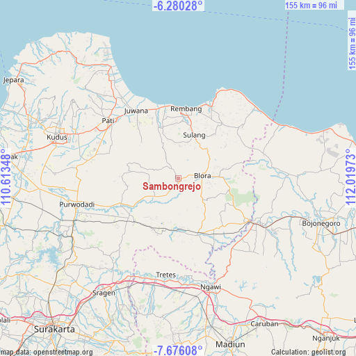
Sambongrejo GPS coordinates[2]
6° 58' 43.32" South, 111° 18' 59.76" East
| Map corner | latitude | longitude |
|---|---|---|
| Upper-left | -6.28028°, | 110.61348° |
| Center: | -6.9787°, | 111.3166° |
| Lower-right: | -7.67608°, | 112.01973° |
| Map W x H: | 155.2×155.2 km | = 96.4×96.4mi |
| max Lat: | 5.88969° ⇑32.3% North |
| Sambongrejo: | -6.9787° |
| min Lat: | ⇓67.7% South -10.934° |
| min Long | Sambongrejo | max Long |
| 95.1345° | 111.3166° | 140.9419° |
| W 38.5%⇐ | ⇒61.5% E |
Elevation
Elevation of Sambongrejo is 105 m = 344 ft, and this is 124.7 m = 409 ft below average elevation for this country.
| Max E: |
3185 m = 10449 ft | 49.2% |
| Avg. | 229.7 m = 754 ft | |
| Sambongrejo | 105 m = 344 ft | |
Min E: |
-1 m = -3 ft | 50.8% |
See also: Indonesia elevation on elevation.city.
Geographical zone
Sambongrejo is located in South Torrid zone (between Equator and Tropic of Capricorn). Distance of Equator is 776 km =482.2 mi to North.| Distance of | km | miles | from Sambongrejo |
|---|---|---|---|
| Equator | 776 | 482.2 | to North |
| Tropic Capricorn | 1830 | 1137.1 | to South |
| Antarctic Circle | 6625.2 | 4116.7 | to South |
| South Pole | 9231.1 | 5735.9 | to South |


Nearby cities:
15 places around Sambongrejo: (largest is in red/bold)
• Beganjing
3.2 km =2 mi,  318°
318°
• Berbak
2.2 km =1.4 mi,  189°
189°
• Bocowanti
1 km =0.6 mi,  24°
24°
• Bradag
2.9 km =1.8 mi,  235°
235°
• Gondang
3.6 km =2.2 mi,  175°
175°
• Gotputuk
1.7 km =1.1 mi,  226°
226°
• Ngawen
2.8 km =1.7 mi, 188°
• Ngrambitan
2.1 km =1.3 mi,  328°
328°
• Pengkolrejo
2.2 km =1.4 mi, 22°
• Pudak
1.5 km =0.9 mi,  137°
137°
• Sendangsari
2.1 km =1.3 mi,  97°
97°
• Suren
1.6 km =1 mi,  292°
292°
• Tawangsari
3 km =1.9 mi,  80°
80°
• Tengger
2.2 km =1.4 mi,  250°
250°
• Wantil
0.8 km =0.5 mi,  52°
52°
Sources, notices
• [Note1] Compared only with cities in Indonesia existing in our database
• [Src1] Map data: © OpenStreetMap contributors (CC-BY-SA)
• [Src2] Other city data from geonames.org with taken over terms of usage.
• [Src3] Geographical zone / Annual Mean Temperature by Robert A. Rohde @ Wikipedia
